|
||

|

|
|

|
Rare Brunswick Edition.
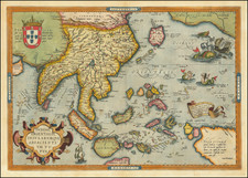
Nice example of Bunting's map of Asia in the shape of the mythical winged horse Pegasus.
The horse is drawn fairly realistically, with a good deal of imagination required to view the map. The head represents Asia Minor, with the mouth at Istanbul. The wings portray Central Asia and Siberia. The Caspian Sea appears horizontally between the wings and the saddle. Persia is delineated on the horse's blanket, with the forelegs forming Arabia. The hind legs represent the Indian and Malay Peninsulas.
The map is among the earliest representations of a landmass in the form of an animal (or human).
Plates and Blocks
Bunting published this map in his Itinerarium, an important religious treatise on biblical geography. The book was illustrated with maps from its first edition in 1581, published in Helmsdadt, but the present map made its first appearance in the 1587 Wittenberg edition.
While the woodblock edition of the map continued to be published in different formats throughout the 16th, 17th, and even 18th centuries, a few editions of the book used a copperplate engraving to illustrate the map. These include the 1592 Prague edition and the 1646 Brunswick editions.
Both copperplate editions can be easily recognized from the lack of the wave pattern present on the woodblock edition:
- The Czech edition can be recognized from the Czech-language text on the verso (instead of Latin or German), as well as the presence of a coat of arms in the lower right corner on the map. The seas are also stippled in this edition.
- The Brunswick leaves the ocean blank and includes additional text below the map.
Henrich Bunting was a Protestant theologian and teacher born in Hanover, in what is now Germany. He attended the University of Wittenberg and graduated in 1569. He then began work as a preacher but caused some controversy with his teachings; he was dismissed from appointments in both Lemgo and Goslar.
He is best known today for his book, Itinerarium Sacrae Scripturae (Travel book through Holy Scripture), a travel collection and commentary of the geography of the Bible. The book provided the most complete summary of biblical geography then available and described the Holy Land by following the travels of various notable people from the Old and New Testaments. First published in Madgeburg in 1581, Itinerarium Sacrae Scripturae was a very popular book for the time. Over 60 editions were published between 1581 and 1757.
A particularly notable feature of the book were its many woodcut maps, many of them showing unique depictions of geographic features and continents. In addition to the conventional maps, the book also contained three figurative maps; the world depicted using a cloverleaf design (thought to possibly represent the Trinity with Jerusalem in the center), Europe in the form of a crowned and robed woman, and Asia as the winged horse Pegasus.
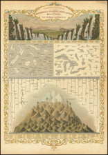
![Plan eines Regulairen Laagers [Plan of a Regular Camp]](https://storage.googleapis.com/raremaps/img/small/93734.jpg)
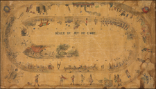
![[Sorority? Hazing in 1931] Cognization to the Class of 1935. . .](https://storage.googleapis.com/raremaps/img/small/81014.jpg)