


|
||

|

|
|

|
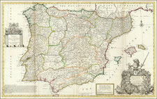
Attractive and decorative mid-17th century map of Spain, showing the delimitations of the various kingdoms and principalities in the country at the time.
The map shows the country in fine detail, with mountains depicted pictorially, rivers, cities, towns, and more all shown. The Balearic isles, part of North Africa, and part of France are also shown.
Nicholas Sanson (1600-1667) is considered the father of French cartography in its golden age from the mid-seventeenth century to the mid-eighteenth. Over the course of his career he produced over 300 maps; they are known for their clean style and extensive research. Sanson was largely responsible for beginning the shift of cartographic production and excellence from Amsterdam to Paris in the later-seventeenth century.
Sanson was born in Abbeville in Picardy. He made his first map at age twenty, a wall map of ancient Gaul. Upon moving to Paris, he gained the attention of Cardinal Richelieu, who made an introduction of Sanson to King Louis XIII. This led to Sanson's tutoring of the king and the granting of the title ingenieur-geographe du roi.
His success can be chalked up to his geographic and research skills, but also to his partnership with Pierre Mariette. Early in his career, Sanson worked primarily with the publisher Melchior Tavernier. Mariette purchased Tavernier’s business in 1644. Sanson worked with Mariette until 1657, when the latter died. Mariette’s son, also Pierre, helped to publish the Cartes générales de toutes les parties du monde (1658), Sanson' atlas and the first French world atlas.
![[ Tracking The Armies of Bonaparte and the English During The Peninsular Campaign ] New Map of Spain and Portugal By E. Mentelle, Member of Institute of Science at Paris, and P. G. Chanlaire, One of the Authors of the National Atlas](https://storage.googleapis.com/raremaps/img/small/99148.jpg)
![[ Bornos and Zahara de la Sierra ] Bornnes [with:] Zahara](https://storage.googleapis.com/raremaps/img/small/96138.jpg)