|
||

|

|
|

|
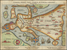
Fine and rare map of Europe showing the continent as it stood during the classical era.
The map names many Roman cities, including Lutetia (Paris), Loniniu (London), Vindobona (Vienna), and, of course, Roma. The regional divisions at the time are shown.
Iceland is referred to as "Thule Insulae," which was the northernmost place known to classical civilization. While today it is thought that this refers to either a Norwegian island or the Orkneys, in the 17th century, it was believed to be a reference to Iceland.
This example of the map is particularly unusual. Adjoined to it, to the left, is a listing of the twelve regions into which Europe is divided on the map. These are in Latin, and names Gallia, Insulae Britannicae, and Illyricum Orientale, among others.
The son of famous French cartographer Nicolas Sanson, Guillaume (1633-1703) carried on his father's work. Like his sire, he was a court geographer to Louis XIV. He often worked in partnership with another prominent cartographer of the time, Hubert Jaillot.
![[ Through Cooperation to Communism ] Spolupraci ke Komunismu](https://storage.googleapis.com/raremaps/img/small/97646.jpg)