


|
||

|

|
|

|
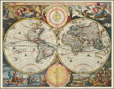
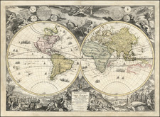
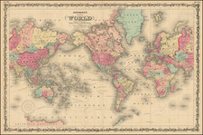
A Master Class of a Wall Map—De Fer’s Map of the World
Rare 1730 Danet state of Nicolas De Fer's monumental double-hemisphere wall map of the world, first published in 1694.
De Fer's map is one of the most decorative wall maps of the world which is reasonably obtainable to the collector. First published in 1694, the map was periodically updated with the newest cartographic discoveries over the next four decades. This state was published by Guillaume Danet, de Fer’s son-in-law.
Engraved by Hendrik van Loon, with decorative embellishments designed and engraved by Nicolaus Guerard, the map is one of the most enduring and iconic French wall maps of the world and would have hung in the salons and libraries of the French aristocracy during the reigns of Louis XIV and Louis XV.
Among the most interesting revisions from earlier states are the additions in Australia and New Zealand. Australia now includes a southern coastline with a curiously large depiction of Van Diemen's Land. New Zealand has been relocated about thirty degrees further to the west; it has more place names and a longer shoreline.
In Northeastern Asia, a strange appendage stretches southward toward Japan. The curving peninsula is “Terre d’Eso ou d’Yeco.” Farther east are two islands labeled, “Terre de la Compagnie” and “Terre vue par Dom Jean de Gama.” The latter continues in the North Pacific in the western hemisphere, suggesting a landmass as wide as a continent.
The other area with major revisions is in North America. California is no longer shown as an island and the Northwest Coast has been reworked. The Strait of Anian remains, suggesting a Northwest Passage.
In the interior of Africa, The Nile River, then as now one of the most important rivers in the word, has a multi-pronged source. The central source stream is in Eastern Africa; indeed, Lake Tana (here Tzana) is the source of the Blue Nile. The other two branches of the Nile, both called the Nubia River, peter out, but one is close to a waterway that leads to the Mountains of the Moon in the south. These mountains are part of a Ptolemaic understanding of the source of the Nile and were common on maps of the time. However, De Fer also strikes a note of caution and states along the equator that it is better to leave this space blank rather than fill it with unknown and imaginary particulars.
At sea, in addition to many ships, are two ships’ tracks. In 1685-6, Alexander, the Chevalier de Chaumont, led a delegation from France to Siam, which today is known as Thailand. This was the second official French trip to Siam; Chaumont was to deliver two ambassadors and to collect delegates from the first delegation of 1684. The route marked here is Chaumont’s voyage to and from Siam from the Cape of Good Hope, and his initial route from Brest to the Cape.
Also included is the Pacific portion of the circumnavigation of Willem Schouten and Jacob Le Maire. The Dutch East India Company (VOC) had declared the Straights of Magellan as their own, disallowing non-VOC ships from entering. In an attempt to circumvent these restrictions, the merchant Isaac LeMaire, Jacob’s father, financed a voyage to find an alternative route in 1615. William Schouten and Isaac Le Maire entered the Pacific from the West via a straight that sent their ships around Cape Horn, which they named for their port of departure in the Netherlands. Le Maire’s name was chosen for the Strait, while the island they passed by received the name of Staten Landt. The Schouten and Le Maire expedition also named the Barnevelt Islands after Johan van Oldenbarnevelt, governor of the province of Holland.
This map also shows Brouwer’s Strait. As part of a Dutch West Indies Company expedition to Chile, Brouwer led a fleet from Recife, Brazil in 1643. The Company wanted to join a revolt already started by the Araucano Indians in an attempt to destabilize the Spanish hold on power. Brouwer had his fleet sail on an easterly route, discovering that Le Maire’s Staten Land was insular.
In the border of the hemispheres are notes. To the west, the running text identifies the various climactic zones: torrid, frigid, and temperate. On the eastern hemisphere is a commentary on the choice of the prime meridian under the reign of Louis XIII, which passes through l’Isle de Fer (Ferro Island).
The surrounding decorations are almost as much an appeal for this map as are the geographical features. Along the top are images of Saturn, Jupiter, Mars, Venus, and Mercury, based upon the ideas of Cassini. Larger are plans of the sun, according to Kircher, and the moon, according again to Cassini.
At the top is a large tableau which displays gods and goddesses, zodiac figures, winds and mythological scenes, all after heavenly pursuits. The lower part of the map depicts mankind at terrestrial pursuits all around the world.
The cartouche, at the lower center, between the hemispheres. Two women, in classical garb, are surrounded by objects signifying bounty and mapmaking. Cherubs are around, aiding them.
Rarity
De Fer’s world map is rare in all its states. This is only the second example of the 1730 state that we have offered in the past twenty years.
This strait, believed to separate northwestern America from northeastern Asia, was related to the centuries-long quest to find a Northwest Passage connecting the Atlantic Ocean to the Pacific. The rumor of this strait and a Northwest Passage in general inspired many voyages of discovery, including those of John Cabot, Sir Francis Drake, Gaspar Corte-Real, Jacques Cartier, and Sir Humphrey Gilbert.
The term Anian itself comes from Marco Polo’s thirteenth-century accounts of his travels. Polo used the term to refer to the Gulf of Tonkin, but cartographers thought it could refer to this supposed strait between Asia and North America. The Strait of Anian, so named, first appeared in a 1562 map by Giacomo Gastaldi, and was later adopted by Bolognini Zaltieri and Gerard Mercator.
North Pacific chimeras: Yesso, De Gama, and Compagnie Land
The etymology of the idiom Yesso (Eso, Yeco, Jesso, Yedso) is most likely the Japanese Ezo-chi; a term used for the lands north of the island of Honshu. During the Edō period (1600-1886), it came to represent the ‘foreigners’ on the Kuril and Sakhalin islands. As European traders came into contact with the Japanese in the seventeenth century, the term was transferred onto European maps, where it was often associated with the island of Hokkaido. It varies on maps from a small island to a near-continent sized mass that stretches from Asia to Alaska.
The toponym held interest for Europeans because the island was supposedly tied to mythic riches. Father Francis Xavier (1506-1552), an early Jesuit missionary to Japan and China, related stories that immense silver mines were to be found on a secluded Japanese island; these stories were echoed in Spanish reports. The rumors became so tenacious and tantalizing that Abraham Ortelius included an island of silver north of Japan on his 1589 map of the Pacific.
Yesso is often tied to two other mythical North Pacific lands, Gamaland and Compagnies Land. Juan de Gama, the grandson of Vasco de Gama, was a Portuguese navigator who was accused of illegal trading with the Spanish in the East Indies. Gama fled and sailed from Macau to Japan in the later sixteenth century. He then struck out east, across the Pacific, and supposedly saw lands in the North Pacific. These lands were initially shown as small islands on Portuguese charts, but ballooned into a continent-sized landmass in later representations.
Several voyagers sought out these chimerical islands, including the Dutchmen Matthijs Hendrickszoon Quast in 1639 and Maarten Gerritszoon Vries in 1643. Compagnies Land, often shown along with Staten Land, were islands sighted by Vries on his 1643 voyage. He named the islands for the Dutch States General (Staten Land) and for the Dutch East India Company (VOC) (Compagnies, or Company’s Land). In reality, he had re-discovered two of the Kuril Islands. However, other mapmakers latched onto Compagnies Land in particular, enlarging and merging it with Yesso and/or Gamaland.
In the mid-eighteenth century, Vitus Bering, a Danish explorer in Russian employ, and later James Cook would both check the area and find nothing. La Perouse also sought the huge islands, but found only the Kurils, putting to rest the myth of the continent-sized dream lands.
Nicholas de Fer (1646-1720) was the son of a map seller, Antoine de Fer, and grew to be one of the most well-known mapmakers in France in the seventeenth century. He was apprenticed at twelve years old to Louis Spirinx, an engraver. When his father died in 1673, Nicholas helped his mother run the business until 1687, when he became the sole proprietor.
His earliest known work is a map of the Canal of Languedoc in 1669, while some of his earliest engravings are in the revised edition of Methode pour Apprendre Facilement la Geographie (1685). In 1697, he published his first world atlas. Perhaps his most famous map is his wall map of America, published in 1698, with its celebrated beaver scene (engraved by Hendrick van Loon, designed by Nicolas Guerard). After his death in 1720, the business passed to his sons-in-law, Guillaume Danet and Jacques-Francois Benard.
![[Early Photographic Facsimile of the Catalan-Estense World Map]](https://storage.googleapis.com/raremaps/img/small/66756.jpg)