|
||

|

|
|

|
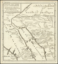
A Plan for an Expanding 19th Century Toluca -- Mexico's Fifth Largest City
Notable plan of Toluca, showing the city as it grew in the late-nineteenth century.
The map shows the state capital nestled between several hills, with a street network that awaited further construction as the city expanded. The town’s center is in the northwest, where the market, the customs house, and the government and city headquarters, and several churches are clustered.
The key in the upper left identifies 52 important landmarks and buildings split into categories: public buildings, principal churches, cemeteries, chapels, theaters, plazas, sentry boxes, and mills. It also identifies a corral and a ballfield. The key also outlines recent changes to street names and notes the population, which was 13,590 (there were 82,363 people in the district and 40,130 in the municipality).
Today, Toluca is the fifth most populous city in Mexico with over 2 million inhabitants. In 1790, Toluca’s population was just over 5,000 people. At that time, it only had eight streets and 845 houses. By 1900, the population had ballooned to just under 26,000.
The plan is a snapshot in the city’s history as it continued to change rapidly. The railroad came in 1882, which reoriented the city significantly. The two cemeteries noted here were ordered closed in 1878, although they continued in some use until the turn of the century. Certain buildings, like the Cathedral (#18) and the Palacio Municipal (#7) are marked as “en obra,” or in progress, when the plan was made. The latter had begun to built in 1872, under the city-wide renovation plans of Marino Riva Palacio, state governor. It was finished in 1883.
At this time, the city was split into eight quarters, or cuarteles, as indicated in the key. These were subdivided into 91 blocks. Inspectors ensured that residents swept in front of their houses and that there was no graffiti, part of a wider effort to clean up and maintain the growing city at this time.
The plan was made by C. Miguel Solalinde, a civil engineer who worked in Toluca during the final three decades of the nineteenth century. Solalinde had many ideas on how to improve the city. For example, in 1894, his plan to systematically rename and number the city’s buildings was adopted. In the same year he also called for a reorganization of the city’s quarters, in light of the population growth and the railroad’s presence in the east of the city. This new system superseded the eight quarters outlined in Solalinde’s plan of 1877. Interestingly, Solalinde is honored in Toluca today with a street named for him, a fitting tribute to a man who dedicated his career to naming and ordering the city.
Toluca
Toluca was founded by the Matlatzincas, who called the settlement Nepintahihui, or land of corn. It developed into a minor city-state known as Tollocan, which means the place of Tolo, a god. Tolutépetl, as it is referred to in some codices, means hill of Tolo and refers to the god and a nearby volcano. The Aztecs made Tollocan a provincial capital with towns in the Toluca Valley paying tribute via the city.
The Spanish invaded in 1521, conquering the valley. Under the Spanish, Tollocan shifted to Toluca. The city was included in the concession made to Hernán Cortés. Religious conversion started in 1524 and some of the first buildings constructed were churches. Spanish settlement began in earnest in 1530, but growth was slow. In 1677, Toluca was recognized as a town; it was upgraded to a city in 1799. The road to Mexico City began to be built in 1793 and the city’s proximity to the metropole is responsible for much of its development.
During the war for independence, in 1811, a group of Indigenous men were killed by Spanish royalists; this square was renamed Plaza de los Martires, or martyrs, in their honor (#34 on the map). The first city council sat in 1812. In 1830, Toluca was selected as the capital of the State of Mexico, cementing its importance. Many cultural sites were opened at mid-century, including Ignacio Ramírez’s Institute of Literature in 1847 (#3) and the Teatro Principal in 1851 (#31).
Rarity
The plan is extremely rare.
The plan is unlisted in OCLC and we find no auction or dealer sales records. We note only the example described in the references below.
![(Mexican-Aztec Paintings) [Original watercolor of 4 Aztec Festival Deities]: Veitecuilitl, Miccailhhuitl, Festival of the Dead, Veymiccailhuitl, Ochpaniztl](https://storage.googleapis.com/raremaps/img/small/103004.jpg)