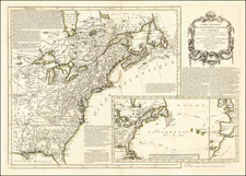
![[ Early United States Map ] Carte Des Etats-Unis De L'Amerique Septentrionale, dresse d'apres des Cartes Anglaises… By Louis Brion de la Tour](https://storage.googleapis.com/raremaps/img/small/39783.jpg)


|
||

|

|
|

|
One of the earliest obtainable maps to name the US. Shows colonies, but limits them to the region east of the Alleghanys & Appalachians. The west remains French & Indian, with forts, settlements, Indian tribes, etc. Nicely detailed & important map. Still no Vermont. Detroit is shown. The Country of the Six Nations is shown, as are a number of early Western Forts. A nice example of this scarce map, which rarely appears on the market, even rarer with the decorative borders.
Louis Brion de la Tour (ca. 1743-1803) was a French geographer and demographer. Little is known about Louis’ early life, but some glimpses of his professional life survive. He did achieve the title of Ingénieur Géographe du Roi. Much of his work was done in partnership with Louis Charles Desnos, who was bookseller and geographical engineer for globes to the Danish Crown. He worked on the Indicateur fidèle ou guide des voyageurs, qui enseigne toutes les routes royales between 1762 and 1785. During his career he also worked on several atlases. By 1795, he had gained a pension from the National Assembly. Perhaps this pension was granted in part because his son, also Louis Brion de la Tour (1763-1823), was an engraver who made Revolutionary prints, as well as maps.