


|
||

|

|
|

|
An American Revolutionary War Rarity -- An early British broadside chart and map illustrating the theater of the American Revolution.
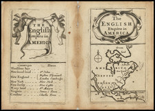
Fine example of Sayer & Bennett's rare November 20, 1776 broadside map and account of the war in North America, which also includes one of the few contemporary printings of Lewis Evan’s Polymetric Table of America, etc. & “Survey of the British Colonies, by Thomas Templeman”.
This is the second of two similar looking broadsides, issued in 1776 by Sayer & Bennett. The March 1776 broadside included an inferior map and significantly less statistical details and was swiftly replaced by the November 1776 broadside.
March 1776 Broadside
Following a brief peace attempt between England and the Colonies in 1775, the American Revolution commenced in earnest in the winter of 1775. Sayer & Bennett's Theatre of War in North America . . . and the accompanying Compendious Account . . are among the earliest contemporary printed accounts of the Revolutionary War available to the British populous, the first printing coming in March 1776, even as the British were evacuating Boston.
The purpose of the map and broadside was to give the British public an overview of the colonies in which the conflict was developing. The map occupies the upper portion, with the colonies described in the letterpress below. At the upper right is a table of the distances which must have been enlightening to the English who imagined the colonies to be much smaller and close together. In addition, a population chart lists Virginia and Maryland's population of "Men (White and Black) able to bear Arms" at 180,000. On Virginia, the publishers note that the colony "seems unrivaled throughout the universe for convenience of inland navigation; indeed, it has been observed, and with reason, that every planter here has a river at his door."
November 1776 Broadside
By November 1776, Sayer & Bennett had certainly recognized that their original map was substantially inaccurate, and omitted the southern part of Florida. To remedy the situation, an entirely new Theatre of War map was issued, using a newly engraved copperplate, with significant improvements throughout. The most obvious changes are:
- Lake Champlain now incorporates the Brassier Survey
- The detail in the Hudson Valley is significantly updated
- The shape of Long Island is significantly improved
- The treatment of Lake Superior, Lake Michigan and Lake Huron are dramatically updated, including a shift of Lake Michigan from trending southeast to trending southwest.
- The details in Western Virginia and the Ohio Valley are significantly updated
- The Upper Mississippi River Valley and Tributaries are significantly revised
- The treatment of North Carolina and Virginia are significantly improved
- The area around Montreal and the St. Lawrence River to the east are significantly updated.
- Title moved from top of map to a cartouche in the center
- Thomas Templeman survey table is added below the Evans table.
Rarity
While the March 1776 broadside and map appear on the market with some frequency, this November 1776 map is quite rare.
We note only an example in the Goodspeed Catalog of 1959 ,ad examples offered by Richard Arkway in 1994 (Catalog 42, item 19) and Martayan Lan in 1999 (Catalog 28, Item 25).
We locate example at the Library of Congress, Boston Public Library, National Library of Portugal, and Colonial Williamsburg.
Robert Sayer (ca. 1724-1794) was a prominent London map publisher. Robert’s father was a lawyer, but his older brother married Mary Overton, the widow of prominent mapmaker Philip Overton and the proprietor of his shop after his death. Mary continued the business for roughly a year after her marriage and then, in early 1748, it passed to Robert. Robert became a freeman of the Stationers’ Company later that year; his first advertisement as an independent publisher was released in December.
Sayer benefited from Overton’s considerable stock, which included the plates of John Senex. In the 1750s, Sayer specialized in design books and topographical prints, as well as comic mezzotints. In 1753, he, along with John Roque, published a new edition of Thomas Read’s Small British Atlas, the first of several county atlases that Sayer would publish.
Sayer’s business continued to grow. In 1760 he moved further down Fleet Street to larger premises at 53 Fleet Street. In 1766, he acquired Thomas Jefferys’ stock when the latter went bankrupt. In 1774, he entered into a partnership with John Bennett, his former apprentice. The pair specialized in American atlases, based on the work of Jefferys. They also began publishing navigational charts in the 1780s and quickly became the largest supplier of British charts in the trade.
Bennett’s mental health declined, and the partnership ended in 1784. As Sayer aged, he relied on his employees Robert Laurie and James Whittle, who eventually succeeded him. He spent more and more time at his house in Richmond. In 1794, he died in Bath.
John Bennett (fl. 1760-d. 1787) was a London printer best known for his role in the successful partnership of Sayer & Bennett. In 1760, Bennett became a servant of Robert Sayer (ca. 1724-1794), the prominent print and map seller, and was apprenticed to him in 1765. In 1774, Bennett became a free journeyman and entered into a partnership with Sayer. They issued joint advertisements and publications. In 1777, Bennett owned 1/3 share in the business. The partnership was likely to continue fruitfully, but in 1781 Bennett began to show signs of mental illness. In 1783, he was admitted to an asylum for nine months and, in 1784, Sayer filed papers to dissolve their business partnership. Bennett died in 1787.
![America [Manuscript Map Showing the Sea of the West!]](https://storage.googleapis.com/raremaps/img/small/41297dm.jpg)
![Nord-Amerika [North America]](https://storage.googleapis.com/raremaps/img/small/91328.jpg)