|
||

|

|
|

|
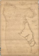
Rare (previously unknow) sea chart of the Gulf of Mexico, published in London by J.S. Hobbs.
Originally issued January 1, 1848, inthe month prior to the signing of the Treaty of Guadalupe Hidalgo on February 2, 1848, the chart provides a finely detailed accounting of the settlements along the Gulf Coast, from Florida to Louisiana and the recently annexed Texas.
The map includes 4 compass roses which illustrate "True" and "Magnetic" North, with rhumb lines radiating outward. A note in the Gulf of Mexico, states "Throughout the Gulf of Mexico & Seas Adjacent, Northerly Winds are most prevalent from October to March."
At the top right, the chart includes views of Lighthouses in Abaco and Gun Cay (Bahamas). Additional lighthouses are identified throughout the carts with red ink and yellow. The chart includes additional insets maps of
- Entrances to the Mississippi River
- Bar and Entrances of Mobile Bay
- Pensacola Harbor
- Port of Vera Cruz
- Galveston Island and vicinity
- San Luis Island on off the South end of Galveston
- Tampico Harbr
- Mouth of the Sabine River
Rarity
The chart is apparently a unique survival. We note no examples of the 1848 or 1856 edition in any reference, OCLC, dealer or auction records.

![[Texas & Oklahoma] Amer. Sep. No. 55. Partie Des Etats-Unis](https://storage.googleapis.com/raremaps/img/small/93537.jpg)