|
||

|

|
|

|
Promoting Virginia As A Hub of Commerce After The Civil War, Including An Important Map of Virginia
Matthew Fontaine Maury's important work promoting post-Civil War Virginia and its commercial attributes, published by the Virginia Military Institute (VMI).
This scarce and important work includes Maury’s updated version of the Bucholtz-Ludwig map of Virginia and two other maps illustrating Virginia.
After the Civil War, Maury, who had been serving the Confederacy in Europe, remained abroad. Following Maury's pardon by the Federal Government in 1868, he returned to VMI to teach physics. Among his first duties was to conduct a “physical survey of Virginia”, the objects of which were to:
… develop the physical resources of the State, to make known its geography, and to point out the great commercial advantages which naturally arise from its situation with regard to the sea and the interior; to show the national importance of that situation and the benefits to arise from turning it to account; also to collect from the people all the information already possessed by them, as to the climate, soil, and productions of the State, its mineral resources, water power and manufacturing facilities, to the end that industry may be stimulated, enterprise encouraged, the material prosperity of the people advanced, and the general welfare of the country promoted.” (Preliminary Report No. 1, p. 3)
As part of the work, an entirely new map of Virginia based on a sophisticated “trigonometric” survey was to be prepared, replacing Ludwig Bucholtz’ 1858 Map of the State of Virginia. However, by the time Maury began work in the summer of 1868, the Transcontinental Railroad was nearly complete. As such, the urgency for competition required Maury to rush into print this Preliminary Report No. 1, whose goals included:
… pointing out [Virginia’s] commercial advantages, its bearing upon the common defence and the national importance which it gives to the two grand lines of internal improvement which are designed to connect the Western States with our seaport towns.
As such, Preliminary Report No. 1 surveyed the economic, geographic and geopolitical merits of Hampton Roads and the city of Norfolk as a primary port of entry for the East Coast, promoting the prospects of a second transcontinental rail line (the Southern Pacific) and of rail and water connections linking the two lines to the lower Chesapeake Bay. In support, three maps were included:
- STEAM LINE BETWEEN NORFOLK & FLUSHING Showing the back country geographically tributary to each, and the internal improvements connected therewith. 1868. (44.7 x 8.2 inches)
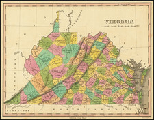
- VIRGINIA MILITARY INSTITUTE MAP OF VIRGINIA Compiled chiefly from C.L. Ludwig’s Map and from other more recent data… by M. F. Maury L.L.D. &c. Prof. Physics V.M.I. Dec. 1868. (35 x 18.5 inches)
- MAP OF THE United States… BY J.H. Waddell, Asst. Prof. of Drawing; prepared under the instructions of M.F.MAURY, L.L.D. Prof. of Physics, V.M.I. Sept., 1868. (26.2 x 18 inches)
Maury's Map of Virginia
The map included in the pamphlet is the third edition of the so-called Bucholtz-Ludwig map of Virginia.
The Bucholtz-Ludwig map was originally based upon work done by Ludwig von Bucholtz, in connection with his updating of the Herman Boye map of Virginia in 1858. Bucholtz was hired to re-engrave the copperplates for the 4 and 9 sheet maps of Virginia originally made by Herman Boye in 1826. The ultimate products of his work were the very large (ca. 29 7/8" x 47", and ca. 62" x 93") maps of Virginia called the Boye-Bucholtz maps. As noted by Wooldridge:
Because Bucholtz had to work from Boye's existing 1826 copperplates, there was dissatisfaction even in 1859 with the Boye revision project. Francis H. Smith, Superintendent of Virginia Military Institute, wrote that the "bill appropriating $8000 under the plan of Mr. Bucholtz might as well direct so much money to be thrown into the James River."
According to E. M. Sanchez-Saavedra, "The knowledge Bucholtz gained on the revision project enabled him to produce several other state maps in the late 1850s. . . all of them geographically superior [to the Boye-Bucholtz map] because they were not superimposed upon incorrect copperplates." A Description of the Country, Virginia's Cartographers and Their Maps 1607-1881, p. 68 (Virginia State Library, Richmond 1975).
The first map in the sequence is Bucholtz's Map of the State of Virginia Containing the Counties, Principal Towns, Railroads Rivers, Canals & All Other/ internal Improvements Lithographed & Published by/ Ritchie & Dunnavant Richmond, Va. 1858 . . . prepared by L. Bucholtz Eng. by Ch. Ludwig. This map was vastly superior in detail and accuracy to Bucholtz's revison to the Herman Boye map. During the Civil War, the map was re-issued by West & Johnston in 1862 and 1864, under the title Map of the State of Virginia. Containing/ the Counties, Principal Towns, Railroads/ Rivers, Canals & All Other Internal Improvements Published by West & Johnston Richmond Va. As noted by Wooldridge:
There are minor geographic changes from Map 1 on Map 2. For example, on Map 2 Jerusalem in Southampton Co. has been moved a little to the northwest of its Map 1 location near the Seaboard and Roanoke Railroad, and the road between the two points imperfectly erased (the remaining shadow is additional evidence that the Map 1 stone was involved). Still, for the most part, Map 1 and Map 2 are the same map.
In 1868, the map was re-issued at under the direction of Matthew Fontaine Maury, under the title Virginia Military Institute Map of Virginia/ Compiled chiefly from C. L. Ludwig's Map and from other more recent data To accompany Preliminary Report of the Physical Survey of Virginia by M. F. Maury L.L.D. &c Prof. Physics V.M.I. Dec. 1868 Eng'd by C. L. Ludwig Richmond Va. As noted by Wooldridge:
The table of Rail Roads included on all the other maps . . . has been dropped, and a new title and imprint inserted . . . . The top 4 3/4 inches inside the neat line of maps 1 and 2, with the original large title and state seal, are cut off. The sliver of Pennsylvania between the Youghiogheny River in the West and Gettysburg in the East is completely blank, while the engraving extends through the country to the left and right of the blank area. . . .
Matthew Fontaine Maury offered it as "a map of the State less erroneous than any hitherto published." There are some changes from 1858. For example, it adds a projected Norfolk & Great Western Railroad through Southside Virginia. In Southampton Co., Jerusalem, located on Map 1 near the Seaboard and Roanoke Railroad and on Map 2 northwest of there, lies on Map 3 on the projected Norfolk & Great Western Railroad. Maps 1 and 2 measure longitude only from Washington while Maps 3 and 4 show degrees from Washington along the top border and degrees from Greenwich along the bottom.
In his article on the map, Wooldridge provides a marvelous discussion of the history of the Maury edition of the map, through excerpts from the Maury papers at the Library of Congress:
In 1868 General Francis H. Smith, Superintendent of the Virginia Military Institute, succeeded in persuading Matthew Fontaine Maury, the "Pathfinder of the Seas," who was then living in England, to return to Virginia to become professor of physics at VMI and to prepare a "physical survey of Virginia."
Smith had long been interested in creating, under VMI auspices, a better map of Virginia. Before the Civil War, he had written at length of his plan for "an accurate Geographical map based upon a careful triangulation of the State and such astronomical observations as would fix geographically the principal points in the primary triangulation."
Picking up after the War, Smith presented in the 1867 report of VMI's Board of Visitors an elaborate plan for the school to develop "a complete geographical and geological map" of Virginia as part of a work on "the entire physical geography of the state." Smith correctly predicted that the importance of this project would lure Maury back to Virginia.
Having accepted Smith's proposal, in the spring of 1868 Maury wrote Smith that the surveying parties would need instruments and suggested that he, Maury, obtain them while he was still in England. Maury recommended twelve pocket barometers, at $12 each, which would enable one to measure altitudes "as you ride about the country."
Maury sailed from England July 1, 1868. Smith busied himself assembling cartographic materials for Maury: 15 local maps of the Valley of Virginia, courtesy of General Robert E. Lee at neighboring Washington College, drafts of maps by Thomas H. Williamson, the professor of engineering and drawing at VMI, geological information from Col. [M.] McDo[nald, head of VMI's department of Minerology and Geology].
One offer of help came from farther afield. Marcus Ammen wrote from the Davenport Female College in Lenoir, Caldwell Co. NC, to solicit employment on the project as a "Topographist." He had done such work in the late war for General Beauregard, J.E.B. Stuart, Fitz Hugh Lee, Rosser, and others. He had spent eight months making a map of Fairfax Co. VA for Beauregard. Now he was a "Portrait and Landscape Painter by profession."
Stonewall Jackson's old mapmaker, Jedediah Hotchkiss, from Staunton volunteered to show Maury his maps of Augusta and other counties of the state.
Notwithstanding all the possible resources for a new map, there was not enough time (and probably not enough money) to carry out the process of surveying, triangulating, taking astronomical observations, and compiling a new map of Virginia as envisaged by General Smith. Maury would not have reached America until July 1868 and the first edition of the Preliminary Report for the physical survey went to the printer in December 1868. Some time in the fall of 1868 Smith and Maury must have decided to use the 1858 Bucholtz map (Map 1) with some changes. Bucholtz's engraver, Charles Ludwig, was still in business in Richmond and had access to the 1858 stone or some derivative stone.
While the rationale for adopting the old map does not seem to be spelled out in the Maury papers, the papers do show that Maury got his Virginia map from Ludwig. The title of the Maury map says "Compiled chiefly from C. L. Ludwig's Map, and from other more recent data," and separately credits Ludwig as engraver. Maury wrote General Smith from Richmond that "Ludwig has 1000 or more of his maps 1 & 2 worked off & yesterday I returned revise [sic - revisions?] to him." Maury sent the maps from Richmond to Baltimore for inclusion in the printed pamphlet . . .When he thought about a second edition, Maury wrote General Smith
The greatest delay will I apprehend be with Ludwig and the map of Virginia. Wherever you have the printing done, it is fair that he should have that map if he will multiply stones & bind himself to come up to time.
Two weeks later, Maury repeated to General Smith, "I do not think it would be quite fair to Ludwig to use in the next edition the present map of Virginia without his consent." Maury suggested paying Ludwig $100 for the use of it in the second edition. In the upshot, they used Ludwig's map only in the first edition (i.e., Map 3). The second edition (1869) had a new Virginia map by James H. Waddell.
A fourth edition of the map, entitled 4. Virginia Military Institute Map of Virginia And West Virginia 1858 . . . , was also issued, although Wooldridge in his article on the map notes that it is almost certain that this map was in fact published in 1869.
Rarity
The map is very rare on the market.
Maury's Physical Survey of Virginia is rare on the market. No examples of the 1868 edition have been offered at auction in the past 30 years.
![(City Views - World and Iberian Peninsula) Illustriorum Hispaniae Urbium Tabulae, cum Appendice Celebriorum Alibi aut olim aut nunc Parentium HIspanis, Aut euroum Civitatum Commerciis florentium. [Maps of the Most Famous Cities in Spain, with an Appendix of Other Notable Cities, Either Formerly or Currently Associated with Spain, or Prominent in the Trade of European Cities.]](https://storage.googleapis.com/raremaps/img/small/94019.jpg)