


|
||

|

|
|

|
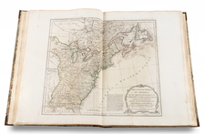
The Definitive Atlas of the American Revolution.
A handsome example of the most important atlas of what would become the United States published during the American Revolution.
Thomas Jefferys's American Atlas (somewhat erroneously titled as the famous Jefferys had died five years earlier, and been replaced by a son who was barely involved in the business) represented the definitive compilation of maps of the North American Colonies when it was published in 1775. The present example is the 1776 issue, published by Sayer & Bennett in London as a reaction to the outbreak of war.
This 1776, includes "A New Map of the Province of Quebec," which represents a significant addition, in place of Jeffreys's "The Middle British Colonies," and the second issue of Samuel Holland's "The Provinces of New York and New Jersey," published on 20 December 1775.
Sayer & Bennett refers to the partnership of Robert Sayer (ca. 1724-1794) and John Bennett (fl. 1760-d.1787), which lasted between 1774 and 1783. Bennett had been Sayer’s apprentice. The pair specialized in American atlases, based on the work of Thomas Jefferys, who plates had been acquired by Sayer when Jefferys went bankrupt in 1766. They also began publishing navigational charts in the 1780s and quickly became the largest supplier of British charts in the trade. However, in 1783 Bennett lost control of his mental faculties and the partnership dissolved as a result. Sayer’s business was later passed to his employees, Robert Laurie and James Whittle.

![(The Wardington Copy) De Vyerighe Colom Klaer Vertoonende in vyftich onderscheydene Curieuse Caarten De XVII Nederlantsche Provincien, Alsmede De Hartogen. . . [The Flaming Column, Clearly Showing in Fifty Different Curious Maps the Seventeen Dutch Provinces, as well as the Dukes...]](https://storage.googleapis.com/raremaps/img/small/89628.jpg)