The item illustrated and described below is sold, but we
have another example in stock. To view the example which
is currently being offered for sale, click the
"View Details" button below.
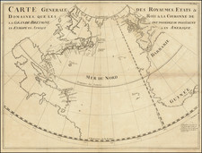
1750 I.A. Schanaebel / George Bickham
$ 475.00


|
||

|

|
|

|
Stock# 81681
Description
Rare variant edition of this unusual map of the North Sea (Atlantic Ocean) from the Polar Circle to the Equator, showing much of North America, the Caribbean, and parts of Europe and Africa.
The map is apparently a rare French edition of the map first issued in George Bickham's British Monarchy c.1740, but this map is substantially larger.
The detail in the British Colonies in North America includes Carolina, Virginia, Maryland, Pennsylvania, New York and New England. Very curious projection of Florida.
A rare and fascinating map. Narrow upper margin.
![[The Rarest State] Americae Sive Novi Orbis Nova Descriptio](https://storage.googleapis.com/raremaps/img/small/80521.jpg)