|
||

|

|
|

|
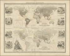
Stunning World Map Showing the Sea of the West
Fine example of the Clouet-Mondhare double-hemisphere world map, showing the Sea of the West, as well as an inland Antarctic Sea and an unusual eastern shoreline of Australia.
This is a rare first edition of this decorative map. The map was reprinted in at least one other state, in 1785, with some additional ship’s tracks added.
World maps featuring ornate borders like this one are uncommon for the late-eighteenth century; they were more typical in the seventeenth century. This map combines a large border with Biblical vignettes, an interior border with astronomical models, and the inner geographic hemispheres.
The twenty images ringing the map are vignettes of Old Testament stories. They are explained in both French and Spanish; a reflection of Clouet’s international business, with shops in both Paris and Cadiz.
Moving inward, in the corners are the solar system models of Tycho Brahe, Descartes, Ptolemy, and Copernicus. They are interspersed with slightly smaller models of solar and lunar eclipses, while at bottom center there is a large armillary sphere. Supporting the geographic hemispheres are two Atlases, straining to hold up the cosmos.
The geography of the map is intriguing; it is based on an updated Guillaume De L’Isle world map modified by Philippe Buache. The map includes the routes of a number of important explorers and voyages, showing the routes of Magellan (1520), Mendaña (1595), Quiros (1605), Le Maire (1615), Tasman (1642), Halley (1700), the St. Louis (1709), the St. Antoine (1710), and Bouvet (1738-9).
It also incorporates the Russian discoveries in Alaska, as well as Buache’s ideas about the interior geography of the Pacific Northwest. The first (1728-30) and second (1722-41) Bering Expeditions redrew the known features of the far northern Pacific by encountering and charting the Alaskan mainland and islands, as well as the Bering Strait. Buache merged this information, as well as that of more dubious sources, like the Admiral de La Fonte’s letters, in a series of maps produced in the early 1750s. The speculative geography is repeated here, including Fonte’s far northern inlet and lakes, as well as the findings of Juan de Fuca and Martin Aguilar.
Near the Sea of the West is the label, “Foussang des Chinois.” This note stems from the work of French Orientalist Le Guignes, who hypothesized that the Chinese arrived in the New World over a millennium before the Europeans in his 1761 work, Recherches sur les Navigations des Chinois du Cote de l'Amerique, et sur quelques Peuples situés a l'extremite orientale de l"asie. Le Guignes was named a fellow of the Royal Society of London in 1752 and his work was well known across Enlightenment Europe and integrated into the maps of Buache and others.
The map also includes allusions to enduring discussions that involved Buache and which entranced French savants in particular. The first of these was the aforementioned Sea of the West, which had sparked controversy in the 1750s and continued to be a bone of contention for geographers in France and Britain especially. The second was the inland sea of the Terres Australes, based on conjectural work by Philippe Buache. The third was the assumed eastern coastline of Australia.
Quiros and Espiritu Santo
Despite the findings of Cook’s first voyage that were published in the early 1770s, the map adopts a particular and somewhat peculiar configuration for Australia that includes a prospective eastern coastline which extends all the way to 180°E. Two rivers flow to that far shore, the Jordan and the St. Salvador.
These rivers are part of Terre du St. Esprit. This toponym connects the speculative coastline to the voyages of Pedro Ferdinand de Quiros at the turn of the seventeenth century. Quiros was a skilled pilot who accompanied Alvaro de Mendaña on his second voyage to the Solomons in 1595-6 (the first voyage took place in 1567-9).
After returning to Spain, Quiros convinced authorities that he could find Terra Australis, the southern continent, if they gave him ships and supplies. He set out in 1605 and eventually landed in Vanuatu. He mistook one of the islands for the fabled continent and called it Austrialia de Espiritu Santo. The largest island in the chain is still called Espiritu Santo today.
Quiros intended to set up a colony on the supposed continent. He performed a series of elaborate possession rituals and founded a city he called Nueba Hierusalem. The “city” was nestled between two rivers which Quiros called the Jordan and the San Salvador (likely today’s Jordan and Vitthié Rivers). However, his crew forced him to leave. Quiros returned to Mexico, but his second-in-command sailed west, through the strait now bearing his name. Due to state secrecy, however, the strait remained largely unknown until the 1760s.
Upon his return, Quiros revved up his campaign, lobbying once again for a voyage to return to his supposed southern continent. To gain support, Quiros wrote at least fifty memorials to advertise his successes and lay out his plans. Fourteen of these were printed between 1607 and 1614.
The most widely circulated was the Eighth Memorial. In it, he describes Austrialia de Espiritu Santo to be as wide as Europe, Asia Minor, the Caspian Sea, and Persia combined, “in its outline it quarters the entire Globe.” Printed in Madrid in 1608 and Seville in 1609, the Eighth Memorial was reprinted in 1612 by Dutch cartographer Hessel Gerritsz in his Detectio Freti Hudson.
Quiros’ discoveries remained tantalizing and would be revived by geographers for the next two centuries. They were part of the Abbe de Paulmier’s 1664 plan to convert the citizens of the Southern Continent. In the mid-1740s, in his reissue of Harris’ Navigantium atque Itinerantium Bibliotheca, John Campbell explained that it was likely that New Guinea and Van Diemen’s Land were all disparate parts of a large Terra Australis that connected to New Holland. His main source to back up this theory was Quiros’ memorials.
Quiros also featured in other prominent voyage collections of the mid-eighteenth century, namely Charles de Brosses’ Histoire des Navigations aux Terres Australes (Paris: Durand, 1756) and Alexander Dalrymple’s An Historical collection of the several voyages and discoveries in the South Pacific Ocean (London, 1769-71).
A hypothetical eastern coastline for Australia
Cartographically, there was variation in the placement of a hypothetical eastern coastline that included Espiritu Santo. One of the earliest maps to show this depiction seems to have been Guillaume Delisle’s 1714 map of the southern hemisphere. The map shows Espiritu Santo with the Jordan and San Salvador rivers at roughly 185°E (from an Atlantic prime meridian), but it is not connected to New Holland. Others also adopted the idea of an Australian continent stretching to Espiritu Santo, including Richard Cushee in his 38 cm. diameter terrestrial globe of 1731.
The idea of a hypothetical eastern coast, evident in the famed Bonaparte Tasman map, was revived in the 1740s and 1750s. One of the world maps in Campbell’s collection, by Emmanuel Bowen, shows T. de St. Espirit at 150°E (Greenwich meridian) as part of a suggested eastern coastline for Australia.
In 1753, Bellin connected Van Diemen’s Land to Espiritu Santo (145°E, Paris meridian), but added a note explaining the link as unproven. Robert de Vaugondy’s map of 1756 also connects the two into a large continent with New Holland (Espiritu Santo at 170°E, with an Atlantic meridian). Interestingly, the latter map was included in De Brosses’ voyage collection, wherein De Brosses expressed his belief that Espiritu Santo was insular.
The most extreme example of the connection of New Holland and Espiritu Santo is seen here on this map, after Buache. In his update of his father-in-law’s world map of 1720, Buache connected the western Dutch discoveries, Van Diemen’s Land, Carpentaria, New Guinea, and Espiritu Santo, which was located at 180°E (Ferro meridian).
Many European maps of North America in the eighteenth century depict a large, western inland sea, hundreds of miles in diameter, with a small inlet to the Pacific and even some interior islands. The origins of this myth can be traced to several different sources and are tied to the search for a Northwest Passage. Like many cartographic myths, the Sea of the West persisted for decades, even in the face of strong evidence pointing to its non-existence.
One of the first European navigators to supposedly explore this area was Martin Aguilar. A Spanish captain, he sailed with Sebastian Vizcaino on a reconnaissance expedition up the California coast in 1602-3. Aguilar, commanding the Tres Reyes, was blown off course, to the north. When the seas calmed, Aguilar reported that he had found the mouth of a large river. Eighteenth-century geographers later conjectured that the river was the entrance to the Sea of the West.
Other maps placed the entrance to the Sea of the West via the Juan de Fuca Strait. Juan de la Fuca is the Castilianized name of Greek navigator Ioánnis Fokás (Phokás). Little archival evidence survives of Fuca’s career, but a chance meeting with an English financier, Michael Lok, in Venice in 1596 gave birth to rumors of Fuca’s voyages in the Pacific. Fuca reported that he had been sent north from New Spain twice in 1592 in search of the Strait of Anian. The Spanish Crown failed to reward Fuca’s discovery of an opening in the coast at roughly 47° N latitude and Fuca left the Spanish service embittered. His story lived on in Lok’s letters and eventually was published in Samuel Purchas’ travel collection of 1625. On many eighteenth-century maps, Fuca’s Strait is linked with a River or Sea of the West. In 1787, the present-day Juan de Fuca Strait was named by the wife of naval explorer Charles William Barkley, making permanent a label that had previously just been hopeful guesswork.
The source of the modern (18th Century) myth of the Sea or Bay of the West (Baye ou Mer de L'Ouest in French), are manuscript maps by Guillaume De L'Isle, who served as the Royal Geographer to the King of France at the end of the 17th Century and beginning of the 18th Century and is widely regarded as the most important map maker of his time. There is a map in Yale's map collection, which depicts a 16th Century Thames school map of North America with a large, "Branch of the South Sea," which closely resembles De L'Isle's Mer de L'Ouest, and may well be the source of De L'Isle's idea.
At the end of the 17th Century, Guillaume De L'Isle had access to the best available maps of the interior of North America, which were being provided from a number of missionary sources, as the French Missionaries pushed west of the Great Lakes and the Mississippi River and obtained information from the indigenous Indian tribes. De L'Isle was regularly producing and updating his manuscript maps in an attempt to integrate new and often conflicting information and improve upon the existing maps of North America. Many of his maps can be viewed as drafts, which were discarded in favor of other and considerably different models.
There are several De L'Isle manuscripts in the Bibliotheque Nationale de France, prepared as early as 1696 (dated), that depict this cartographic myth. Interestingly, while De L'Isle was a prolific publisher of printed maps, he never depicted the Sea or Bay of the West on any of his printed maps, which strongly suggests that he was not able to reconcile this information with the best available source information from America. During this same period, Jean Baptiste Nolin, who had in the prior decade collaborated with Vincenzo Maria Coronelli on his monumental globe for Louis XIV and produced a series of highly important maps of North America and its regions, would have also had access to many of the same reports and maps as De L'Isle. Nolin apparently gave greater credence to the concept than De L'Isle.
The earliest printed map to show the Bay of the West is Jean Baptiste Nolin's rare wall map of the world, published in about 1700. Nolin plagiarized the idea from Guillaume De L'Isle, as he testified when suing Nolin for plagiarism. He said, the Sea of the West “was one of my discoveries. But since it is not always appropriate to publish what one knows or what one thinks one knows, I have not had this sea engraved on the works that I made public, not wanting foreigners to profit from this discovery” (as quoted in Pedley, The Commerce of Cartography, 109). The court sided with De L'Isle and issued an order requiring Nolin to destroy the copper plates for the map (see Shirley 605). Nolin's map was in turn copied by the Mortier family, who issued 3 world maps shortly thereafter, showing Nolin's version of the Sea of the West, but the myth ignored for nearly half a century.
While the myth of the Sea or Bay of the West temporarily languished, the proliferation of Russian exploration off the Northwest Coast of America after 1740, as reported by Guillaume's younger brother Joseph Nicholas De L'Isle, reinvigorated interest in the region and forced the most prominent map makers of the period to re-examine existing knowledge. Joseph Nicolas served as a geographer to the Russian Academy and returned with this information to Paris. The re-introduction of the sea in the mid-eighteenth century was the result of Guillaume De L’Isle’s son-in-law, Philippe Buache’s review of his father-in-law’s papers. Although Guilluame De L’Isle never published a printed map showing the sea, he had postulated that it could exist, and that it might connect to a Northwest Passage through New France, not through English territory farther north.
The sea was a major part of Buache and Joseph-Nicholas Delisle’s maps of the North Pacific, published in the 1750s. While controversial, the features of those maps were quickly copied by other mapmakers, including the Sea of the West. The inland body of water lingered on maps until the later-eighteenth century.
During a period between 1750 and 1770, the most prominent French and British map makers advanced multiple and widely varying theories on the Northwest Coast of America. Denis Diderot dedicates several of the 10 maps in his monumental Encylopedie (1779 and after), to a comprehensive survey of the maps proffered by Joseph Nicholas De L'Isle (Guillaume's brother), Philippe Buache, Thomas Jefferys and others. The debate ended with Captain James Cook's and later George Vancouver and Comte Jean de la Perouse's explorations in the late 18th Century.
Several mid-eighteenth-century maps, initially those of renowned theoretical geographer Philippe Buache, show a hypothetical depiction of what is now called Antarctica. The landmass is split into two with a large Mer Glaciale running through their middle. The smaller of the two is separated from Tierra del Fuego but extends north to land spotted by Bouvet de Lozier in 1739. Across the frozen sea is the larger of the two of Buache’s Antarctic lands. It extends east, running well south of Van Diemen’s Land, which had been skirted by Tasman in his voyage of 1642-3. Farther east in the Pacific the shore twists north to include New Zealand, which was also contacted by Tasman.
Bouvet’s sighting of Cap de la Circoncision is near one of the entrances to the polar sea. The other opening into the inland sea, to the southwest of South America, was placed where the buccaneers Sharpe and Davis had reported icebergs in 1687. Buache believed that the icebergs must have derived from a floating ice sheet, as in the Arctic. This hypothesis led him to conclude that the southern continent was not a single landmass but two islands separated by a frozen inland sea, from which icebergs detached themselves to float northwards.
The inland sea theory was based upon work Buache had developed over a number of years. His ideas were presented to the Académie des Sciences in 1744, published as Considérations géographiques sur les terres australes et antarctiques in 1761, and republished in English in The Gentleman's Magazine in 1763. In it, he hypothesized that the southern pole must contain a frozen sea, fed by mountain ranges and huge rivers in order to produce icebergs of the size reported by Bouvet, Halley, and others. The Antarctic inland sea was much discussed by geographers at the time and it was copied by several other mapmakers.
Jean-Baptiste Louis Clouet (1730-ca. 1790) was a mapmaker with premises in both Paris and Cadiz. He was eventually named Royal Geographer of the Academie des Sciences de Rouen. Although he made several lavish wall maps, he is best known for Geographie Moderne (1776-93).
![De Schepping der Wereldt Volgens de Beschryving van Mozes. 1 Plaat [in set with] De Schepping der Wereldt Volgens de Beschryving van Mozes. 2. Plaat](https://storage.googleapis.com/raremaps/img/small/102641.jpg)