


|
||

|

|
|

|
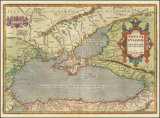
Finely-Colored Example of Ortelius’ Map of the Black Sea and Surrounding Regions in Ancient Times
A fine example of Ortelius’ map of the Black Sea, published in his 1624 edition of the Parergon, an atlas depicting the ancient world. The Parergon was generally published as an appendix to Ortelius’ magnum opus, the Theatrum Orbis Terrarum, which is considered the first modern atlas. However, the Parergon was also published as a separate atlas on a few occasions, including in 1624.
The map is oriented northward, with the directions carefully noted in the center of each edge of the map. The entirety of the Black Sea is displayed, as well as the surrounding regions, including present-day Turkey and Armenia (Bithynia, Galatia, Cappadocia, Armeniae Pars), Georgia and Russia (Colchis, Sarmatiae Asiaticae pars), Ukraine (Scythiae sive sarmatiae Europaeæpa), the Crimean peninsula (Taurica quae et scythica chersonesus), Moldova, Romania, and Bulgaria (Getae, Daciae pars, Pontus Moesia), and Greece (Thraciae pars). The smaller water body connected to the Black Sea to the north is Maeotis Palus (the Maeotis Swamp or Lake Maeotis), which is today known as the Sea of Azov. The sea is colored an appropriate dark grey while the other regions are differentiated by color, alternating between red, green, and yellow.
This map is characterized by excellent attention to detail. The shape of the coastlines and rivers are carefully rendered, and throughout the map mountain ranges and forests give the land texture. Cities are represented with unique drawings in dark red. Each aspect of the map is labeled, and some labels give additional information about the name or events that occurred there. This indicates the map’s use as a reference for the region in both geography and history.
The two cartouches, one containing the title and date and the other the map’s creator, are sharply rendered and brightly colored in red, blue, and yellow. The ornamented edges curl out and are shaded so as to give them a three-dimensional quality that pops from the page. In particular, the decorative title cartouche takes up a large part of the land on the eastern area of the map. The title of the map, Pontus Euxinus, is Latin for “hospitable sea,” a euphemism for the earlier name “inhospitable sea,” as the Black Sea was known for its stormy weather, harsh currents, and lack of islands to visit. Also found in the cartouche is the phrase “Aequor Iasonio pulsatum remige primum,” indicating that this was the sea first traveled by Jason, the ancient Greek hero who sailed to find the Golden Fleece. This places the map firmly in the realm of classical mythology.
The map includes many interesting locations important to Greek mythology. Phryxis’ temple is located on the Phasis river in Colchis (in the southeast corner of the map), which was the location of the Golden Fleece, the object of Jason’s quest. Themiscyra, home to the Amazons and a city visited by Heracles during his Nine Labours, is also present on the southern shore of the Black Sea, between the Iris and Thermodon rivers. There are also numerous cities named for Greek gods and heroes, such as Apollonia Magna on the Thracian coast and Heraclea near the mouth of the Acheron river in Bithynia.
Parergon
Although best known for his world atlas, Theatrum Orbis Terrarum, the Parergon was a project of personal interest and the work that Ortelius himself considered his greatest achievement. He had a deep interest in classical antiquity which spurred him to create the Parergon maps, and the amount of time and detail he put into each map is clearly evident. Rather than copying from existing maps, as he had done for the Theatrum, Ortelius hand-drew each map of the Parergon, which required considerable skill and knowledge of the area’s history and geography. It is considered the first historical atlas.
Parergon means supplementary, and accordingly, the first three Parergon maps were published as supplements to the 1579 edition of the Theatrum, which had already been in print for nine years. Over time, successive editions of the Theatrum were supplemented with more Parergon maps, and there are 55 known plates overall. The Parergon was also published as its own atlas separate from the Theatrum on two occasions, once in 1595 and again in 1624.
The Parergon was highly successful both as a supplement to the Theatrum and on its own. It was variously translated into French, German, Italian, and English and regularly printed until 1612. Further editions were more sporadic but still popular, such as the 1624 edition which was published twenty-six years after Ortelius’ death in 1598.
This beautifully colored map blends geography, history, and myth, and the level of detail present speaks to Ortelius’ skill as a mapmaker and his dedication to his craft. This would be a valuable addition to a collection of Eastern European maps, Ortelius maps, or maps of classical antiquity.
Abraham Ortelius is perhaps the best known and most frequently collected of all sixteenth-century mapmakers. Ortelius started his career as a map colorist. In 1547 he entered the Antwerp guild of St Luke as afsetter van Karten. His early career was as a business man, and most of his journeys before 1560, were for commercial purposes. In 1560, while traveling with Gerard Mercator to Trier, Lorraine, and Poitiers, he seems to have been attracted, largely by Mercator’s influence, towards a career as a scientific geographer. From that point forward, he devoted himself to the compilation of his Theatrum Orbis Terrarum (Theatre of the World), which would become the first modern atlas.
In 1564 he completed his “mappemonde", an eight-sheet map of the world. The only extant copy of this great map is in the library of the University of Basel. Ortelius also published a map of Egypt in 1565, a plan of Brittenburg Castle on the coast of the Netherlands, and a map of Asia, prior to 1570.
On May 20, 1570, Ortelius’ Theatrum Orbis Terrarum first appeared in an edition of 70 maps. By the time of his death in 1598, a total of 25 editions were published including editions in Latin, Italian, German, French, and Dutch. Later editions would also be issued in Spanish and English by Ortelius’ successors, Vrients and Plantin, the former adding a number of maps to the atlas, the final edition of which was issued in 1612. Most of the maps in Ortelius' Theatrum were drawn from the works of a number of other mapmakers from around the world; a list of 87 authors is given by Ortelius himself
In 1573, Ortelius published seventeen supplementary maps under the title of Additamentum Theatri Orbis Terrarum. In 1575 he was appointed geographer to the king of Spain, Philip II, on the recommendation of Arias Montanus, who vouched for his orthodoxy (his family, as early as 1535, had fallen under suspicion of Protestantism). In 1578 he laid the basis of a critical treatment of ancient geography with his Synonymia geographica (issued by the Plantin press at Antwerp and republished as Thesaurus geographicus in 1596). In 1584 he issued his Nomenclator Ptolemaicus, a Parergon (a series of maps illustrating ancient history, sacred and secular). Late in life, he also aided Welser in his edition of the Peutinger Table (1598).
![[ Austro-Turkish War ] Zum ersten quartal des Krigsweisers](https://storage.googleapis.com/raremaps/img/small/97836.jpg)