


|
||

|

|
|

|
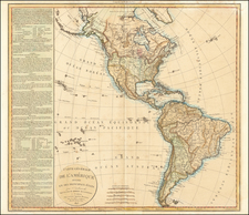
The Western Hemisphere—With Bay, Sea, and River of the West!
Intriguing map of the Western Hemisphere, published by Brion de la Tour in Paris.
The geography of the map encompasses the Americas, with no southern lands, but with many voyage tracks in the Atlantic and the Pacific.
The most interesting portion of the map is the Pacific Northwest, where there are two outlines of Alaska and what appears to be a large inland sea in what is today the American West.
This map encompasses a variety of hypotheses from maps published at mid-century. They include the findings of the First and Second Kamchatka Expedition (1728-1730, 1733-1743), which saw Russians sail up and across the Bering Strait—named for the leader of both expeditions, Vitus Bering—and contact mainland North America for the first time. The outlines included here reflect the work put forth by French mapmakers Buache and De L’Isle and the counter-map suggested by Gerhard Friedrich Müller.
Farther south is a Bay, River, and Sea of the West. The latter configuration was first hypothesized by Guillaume De L’Isle, although he never published a depiction of it. It was revived by his son-in-law, Buache, and brother, Joseph-Nicolas De L’Isle in their above-mentioned work. Other mapmakers thought there could be a river connecting across the continent, or even just a bay. All three ideas are included here, which is unusual.
Along the western coast, three inlets mention three controversial navigators—Juan de Fuca, Martin Aguilar, and Admiral Fonte—whose supposed findings fed the debate over a Northwest Passage. Juan de Fuca is the Castilianized name of Greek navigator Ioánnis Fokás (Phokás). Little archival evidence survives of Fuca's career, but a chance meeting with an English financier, Michael Lok, in Venice in 1596 gave birth to rumors of Fuca's voyages in the Pacific. Fuca reported that he had been sent north from New Spain twice in 1592 in search of the Strait of Anian. The Spanish Crown failed to reward Fuca's discovery of an opening in the coast at roughly 47° N latitude and Fuca left the Spanish service embittered. His story lived on in Lok's letters and eventually was published in Samuel Purchas' travel collection of 1625. In 1787, the present-day Juan de Fuca Strait was named by the wife of naval explorer Charles William Barkley, making permanent a label that had previously just been hopeful conjecture.
Aguilar was a Spanish captain who sailed with Sebastian Vizcaino on a reconnaissance expedition up the California coast in 1602-3. Aguilar, commanding the Tres Reyes, was blown off course, to the north. When the seas calmed, Aguilar reported that he had found the mouth of a large river. Some eighteenth-century geographers conjectured that the river was the entrance to the Sea of the West, although here Müller instead has it as the mouth of a River of the West. This river is one of the most notable features on the map. It connects from the Pacific to Hudson’s Bay and offers a strong suggestion of a navigable Northwest Passage. Whereas Müller had abandoned the grandiose Sea of the West that appeared on Buache and De L’Isle’s 1752 map (and their later maps), he has kept the idea of an inland waterway that could connect Atlantic and Pacific.
Admiral de Fonte supposedly sailed to the area in the mid-seventeenth century. The first mention of Fonte appears in two letters published in London in 1708 in two issues of The Monthly Miscellany or Memoirs for the Curious. The Fonte letters had been reprinted by Arthur Dobbs in his 1744 An Account of the Countries adjoining Hudson's Bay and were mentioned in other travel accounts. The letters recounted that Fonte had found an inlet near 53°N which led to a series of lakes. While sailing northeast, Fonte eventually met with a Boston merchant ship, commanded by a Captain Shapley. One of Fonte's captains, separated from the Admiral, reported he had found no strait between the Pacific and the Davis Straits, yet had reached 79°N, helped by local indigenous peoples. This story, with its suggestion of water passages connecting the Pacific Northwest with the east, inspired hope in some and doubt in others in the mid-eighteenth century. A few, like Irish mapmaker John Green, thought the entire story a farce. Many, including De L'Isle and Buache, thought the information conformed neatly to other recent discoveries and included Fonte on their maps.
The voyage tracks shown here are numerous. They include the track of the Second Kamchatka Expedition, which includes a note near the Bay of the West toponym that mentions Chirikov, who was an officer on the mission, and the Rio de los Reyes, part of the Fonte myth.
Further south are the tracks of Magellan (1520), Mendaña (1595, misdated here to 1508), Quiros (1605), Le Maire (1615), Tasman (1642), Halley (1700), the St. Louis (1709), the St. Antoine (1710), and the Marie and the Aigle, which were vessels commanded by Jean-Baptiste Charles Bouvet de Lozier (1738-9).
Anson’s circumnavigation (1740-44)
Also included are Anson’s track and that of a galleon he sought. In 1739, resentment over Spanish raids of British ships in the Caribbean sparked the War of Jenkin’s Ear, which would widen into the larger War of Austrian Succession. The Commissioners of the British Admiralty planned a global strategy to harass Spanish trade and weaken its over-stretched navy and merchant marine. Anson’s voyage was part of this strategy. He set out in 1740 with a squadron of six ships and 1,900 men.
By 1743, Anson had crossed the Pacific after raiding the west coast of South America. Prior to crossing he had waited off the Mexican coast for the Acapulco galleon, full of silver, to appear, but he only succeeded in blocking the ship from leaving port. Meanwhile, he had also lost five of his ships and 1,400 of his men, primarily to scurvy; only his own ship, Centurion, remained intact.
After repairing at Macao, Anson let Chinese officials know that he was headed for Britain; in reality, he sailed to the Philippines to await the entrance of the Acapulco galleon. Remarkably, considering the voyage prior to that point, the Centurion took the Nuestra Señora de la Covadonga with only light casualties. He was celebrated as a hero upon his return to England with his prize.
Many European maps of North America in the eighteenth century depict a large, western inland sea, hundreds of miles in diameter, with a small inlet to the Pacific and even some interior islands. The origins of this myth can be traced to several different sources and are tied to the search for a Northwest Passage. Like many cartographic myths, the Sea of the West persisted for decades, even in the face of strong evidence pointing to its non-existence.
One of the first European navigators to supposedly explore this area was Martin Aguilar. A Spanish captain, he sailed with Sebastian Vizcaino on a reconnaissance expedition up the California coast in 1602-3. Aguilar, commanding the Tres Reyes, was blown off course, to the north. When the seas calmed, Aguilar reported that he had found the mouth of a large river. Eighteenth-century geographers later conjectured that the river was the entrance to the Sea of the West.
Other maps placed the entrance to the Sea of the West via the Juan de Fuca Strait. Juan de la Fuca is the Castilianized name of Greek navigator Ioánnis Fokás (Phokás). Little archival evidence survives of Fuca’s career, but a chance meeting with an English financier, Michael Lok, in Venice in 1596 gave birth to rumors of Fuca’s voyages in the Pacific. Fuca reported that he had been sent north from New Spain twice in 1592 in search of the Strait of Anian. The Spanish Crown failed to reward Fuca’s discovery of an opening in the coast at roughly 47° N latitude and Fuca left the Spanish service embittered. His story lived on in Lok’s letters and eventually was published in Samuel Purchas’ travel collection of 1625. On many eighteenth-century maps, Fuca’s Strait is linked with a River or Sea of the West. In 1787, the present-day Juan de Fuca Strait was named by the wife of naval explorer Charles William Barkley, making permanent a label that had previously just been hopeful guesswork.
The source of the modern (18th Century) myth of the Sea or Bay of the West (Baye ou Mer de L'Ouest in French), are manuscript maps by Guillaume De L'Isle, who served as the Royal Geographer to the King of France at the end of the 17th Century and beginning of the 18th Century and is widely regarded as the most important map maker of his time. There is a map in Yale's map collection, which depicts a 16th Century Thames school map of North America with a large, "Branch of the South Sea," which closely resembles De L'Isle's Mer de L'Ouest, and may well be the source of De L'Isle's idea.
At the end of the 17th Century, Guillaume De L'Isle had access to the best available maps of the interior of North America, which were being provided from a number of missionary sources, as the French Missionaries pushed west of the Great Lakes and the Mississippi River and obtained information from the indigenous Indian tribes. De L'Isle was regularly producing and updating his manuscript maps in an attempt to integrate new and often conflicting information and improve upon the existing maps of North America. Many of his maps can be viewed as drafts, which were discarded in favor of other and considerably different models.
There are several De L'Isle manuscripts in the Bibliotheque Nationale de France, prepared as early as 1696 (dated), that depict this cartographic myth. Interestingly, while De L'Isle was a prolific publisher of printed maps, he never depicted the Sea or Bay of the West on any of his printed maps, which strongly suggests that he was not able to reconcile this information with the best available source information from America. During this same period, Jean Baptiste Nolin, who had in the prior decade collaborated with Vincenzo Maria Coronelli on his monumental globe for Louis XIV and produced a series of highly important maps of North America and its regions, would have also had access to many of the same reports and maps as De L'Isle. Nolin apparently gave greater credence to the concept than De L'Isle.
The earliest printed map to show the Bay of the West is Jean Baptiste Nolin's rare wall map of the world, published in about 1700. Nolin plagiarized the idea from Guillaume De L'Isle, as he testified when suing Nolin for plagiarism. He said, the Sea of the West “was one of my discoveries. But since it is not always appropriate to publish what one knows or what one thinks one knows, I have not had this sea engraved on the works that I made public, not wanting foreigners to profit from this discovery” (as quoted in Pedley, The Commerce of Cartography, 109). The court sided with De L'Isle and issued an order requiring Nolin to destroy the copper plates for the map (see Shirley 605). Nolin's map was in turn copied by the Mortier family, who issued 3 world maps shortly thereafter, showing Nolin's version of the Sea of the West, but the myth ignored for nearly half a century.
While the myth of the Sea or Bay of the West temporarily languished, the proliferation of Russian exploration off the Northwest Coast of America after 1740, as reported by Guillaume's younger brother Joseph Nicholas De L'Isle, reinvigorated interest in the region and forced the most prominent map makers of the period to re-examine existing knowledge. Joseph Nicolas served as a geographer to the Russian Academy and returned with this information to Paris. The re-introduction of the sea in the mid-eighteenth century was the result of Guillaume De L’Isle’s son-in-law, Philippe Buache’s review of his father-in-law’s papers. Although Guilluame De L’Isle never published a printed map showing the sea, he had postulated that it could exist, and that it might connect to a Northwest Passage through New France, not through English territory farther north.
The sea was a major part of Buache and Joseph-Nicholas Delisle’s maps of the North Pacific, published in the 1750s. While controversial, the features of those maps were quickly copied by other mapmakers, including the Sea of the West. The inland body of water lingered on maps until the later-eighteenth century.
During a period between 1750 and 1770, the most prominent French and British map makers advanced multiple and widely varying theories on the Northwest Coast of America. Denis Diderot dedicates several of the 10 maps in his monumental Encylopedie (1779 and after), to a comprehensive survey of the maps proffered by Joseph Nicholas De L'Isle (Guillaume's brother), Philippe Buache, Thomas Jefferys and others. The debate ended with Captain James Cook's and later George Vancouver and Comte Jean de la Perouse's explorations in the late 18th Century.
Louis Brion de la Tour (ca. 1743-1803) was a French geographer and demographer. Little is known about Louis’ early life, but some glimpses of his professional life survive. He did achieve the title of Ingénieur Géographe du Roi. Much of his work was done in partnership with Louis Charles Desnos, who was bookseller and geographical engineer for globes to the Danish Crown. He worked on the Indicateur fidèle ou guide des voyageurs, qui enseigne toutes les routes royales between 1762 and 1785. During his career he also worked on several atlases. By 1795, he had gained a pension from the National Assembly. Perhaps this pension was granted in part because his son, also Louis Brion de la Tour (1763-1823), was an engraver who made Revolutionary prints, as well as maps.

![Western Hemisphere [and] Eastern Hemisphere](https://storage.googleapis.com/raremaps/img/small/85988.jpg)
![Western Hemisphere [and] Eastern Hemisphere](https://storage.googleapis.com/raremaps/img/small/77831.jpg)
![[Sea of the West] L'Amerique divisee Par Grands Etats . . . 1762](https://storage.googleapis.com/raremaps/img/small/98770.jpg)