|
||

|

|
|

|
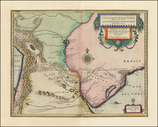
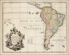
Fine Sea Chart of the Entrance to the Pacific
Striking chart showing the southern part of South America, from Chile and the Rio de la Plata to Patagonia and Tierra del Fuego.
The chart is part of a series of southern South American regional charts by several Dutch makers in the second half of the seventeenth century. The first, with an incomplete coast of Tierra del Fuego, was by Pieter Goos. Doncker’s chart followed, with another, more decorative chart by De Wit issued a few years later.
The chart is covered in crossing rhumb lines, which allow a navigator to plot their course. Important ports include Port Desire, San Julian, Castro, Osorno, and Valdivia. The island of Juan Fernandez, which was a convenient stopping place for ships passing around the south of South America, is in the northwest. Interestingly, there are two Diego Ramirez islands near Cape Horn. The southwest shore of Tierra del Fuego is still only tentatively sketched.
Two ships sail in the South Atlantic. An ornate cartouche houses the title, with two putti frolicking below.
The chart emphasizes the Dutch voyages to the region around the turn of the seventeenth century. The first of these were part of the attempt to trade with China and the Spice Islands and the creation of the Dutch East India Company (VOC). Of the fourteen fleets that set out from Dutch ports for the East Indies between 1598 and 1601, only two did so via the Strait of Magellan.
The first of these was commanded by Jacques Mahu and Simón de Cordes. With five ships and 490 men, Cordes battled the elements to winter at Cordes Bay in the western Straits. He lost 120 men there to privation and encounters with local people. One of the ships were commanded by Sebald de Weert, who turned back. On his way north, he sighted islands that were likely the Falklands, but which appeared on charts for over a century as the Seebald de Weerts (here the Sybold de Waerds Eylanden).
The second of the fleets was in the charge of Olivier van Noort. After killing tens of Selk’nam peoples in the Straits, they eventually caught up to parts of Mahu and Cordes’ ragged squadron. Van Noort set out west and eventually completed a circumnavigation, the first Dutch venture to do so.
The third significant Dutch voyage had the most impact on the geography shown here. The VOC had declared the Straights of Magellan as their own, disallowing non-VOC ships from entering. In an attempt to circumvent these restrictions, the merchant Isaac LeMaire financed a voyage to find an alternative route in 1615. William Schouten and Isaac’s son, Jacob Le Maire, entered the Pacific via a straight that sent their ships around Cape Horn, which they named for their port of departure in the Netherlands. Le Maire’s name was chosen for the strait, while the island they passed by received the name of Staten Land. The Schouten and Le Maire expedition also named the Barnevelt Islands after Johan van Oldenbarnevelt, governor of the province of Holland.
Hendrik Doncker was a prominent bookseller in Amsterdam best known for his sea charts and nautical atlases. He issued his own original charts, which he updated frequently, and also worked with colleagues like Pieter Goos, for example to produce the pilot guide, De Zeespeigel. He died in 1699, after fifty years in business. His plates then passed to Johannes van Keulen.