|
||

|

|
|

|
Stock# 81461
Description
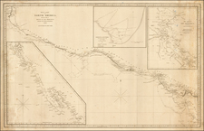
A Curious Blend of Strip Maps and Larger Maps
Highly unusual early road map, showing the major highways in California, Washington and Oregon.
The map includes 10 early strip maps (8 on verso), illustrating various sections of highway between Vancouver and San Diego, with smaller inset maps showing illustrating local cities. Also includes an elaborate mileage table for the west coast.
The map was published by the American Toll Bridge Company, formed in 1923 and operated the Carquinez Bridge and the Antioch Bridge over the San Joaquin River, "Gateway to the Netherlands of America."
![(California Gold Rush Artist) [Autograph Letter, from American artist William McIlvaine Jr. to artist William Thompson Russell Smith, mentioning Fronconia Notch. White Mountains]](https://storage.googleapis.com/raremaps/img/small/97179.jpg)
![[California Wine Advertising Graphic] Italian Swiss Colony Producers of Choicest California Wines Asti Colony Tipo](https://storage.googleapis.com/raremaps/img/small/83467.jpg)
![[ Southern California Tourism ] Hunting and Fishing in Southern California on the Santa Fe](https://storage.googleapis.com/raremaps/img/small/101613.jpg)