|
||

|

|
|

|
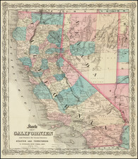
Rare Climate Map of California -- Early Illustration of Viticulture In California
Interesting separately issued map of California, published by the California State Board of Trade.
The map is colored to illustrate 5 different climate zones, illustrating the "Maen Annual Temperature" of each region.
The map also including a remarkable group of lithographic views of California agricultural scenes, including early a scene showing the harvesting of Wine Grapes ("A California Vintage"). This image is one of the earliest illustrations of California viticulture
The map includes significant detail, including counties, towns, roads, railroad, mountains, rivers, lakes, mining information, township surveys, etc.
Other vignettes showing a Suburban Residence Near San Francisco, A California Oak, Coast Range Scenery. Lemons, Fruit Orchards, Cherry Orchards, Rose Trees, and other scenes promoting the fine growing conditions in California.
There were two versions of this map issued in 1888. The other version includes fewer and simpler vignettes and a different text setting for the title. The verso text is also different, most notably different addresses for the California State Board of Trade.
A later variant without color or climate details would be re-issued in 1893, removing two of the vignettes in order to show the roads into Nevada.
Rarity
The map is extremely rare. We locate 3 institutional copies of this version of the map and 2 examples of the variant edition.
![(California Gold Rush) Oregon and California in 1848 in Two Volumes [with:] Map of California, Oregon, Texas, and the Territories adjoining with Routes &c.](https://storage.googleapis.com/raremaps/img/small/82901.jpg)
![[Imperial and San Bernardino Counties] Sketch To Accompany Report of Reconnaissance Head Gate Crossing of Colorado River To Bristol, Cal. March 20, 1903](https://storage.googleapis.com/raremaps/img/small/31857.jpg)