|
||

|

|
|

|
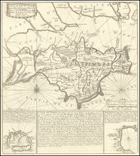
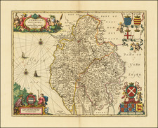
Detailed regional map of England, from Oxfordshire, Herefordshire and Suffolk in the south to Lancastershire and Yorkshire in the north, published by the leading French mapmaker of the mid-17th Century, Nicolas Sanson.
This map provides a historical look at the region when it was ruled by the Kingdom of Mercia, one of the most important Anglo-Saxo predecessors to the Kingdom of England.
Nicolas Sanson (1600-1667), sometimes called Nicolas Sanson d'Abbeville or Sanson d'Abbeville, was the most important French cartographer of the 17th century. Tooley called Sanson "the founder of the French school of cartography." He began making maps in the late 1620s, and in the 1630s he was working with Melchior Tavernier. Later, Sanson worked in concert with the print publisher Pierre Mariette, with whom he published his great atlas: Cartes générales de toutes les parties du monde (1658). After Sanson's death in 1667, his son Guillaume carried on the business in partnership with Alexis Hubert Jaillot. Guillaume established himself as a very important French mapmaker in his own right.
Nicholas Sanson (1600-1667) is considered the father of French cartography in its golden age from the mid-seventeenth century to the mid-eighteenth. Over the course of his career he produced over 300 maps; they are known for their clean style and extensive research. Sanson was largely responsible for beginning the shift of cartographic production and excellence from Amsterdam to Paris in the later-seventeenth century.
Sanson was born in Abbeville in Picardy. He made his first map at age twenty, a wall map of ancient Gaul. Upon moving to Paris, he gained the attention of Cardinal Richelieu, who made an introduction of Sanson to King Louis XIII. This led to Sanson's tutoring of the king and the granting of the title ingenieur-geographe du roi.
His success can be chalked up to his geographic and research skills, but also to his partnership with Pierre Mariette. Early in his career, Sanson worked primarily with the publisher Melchior Tavernier. Mariette purchased Tavernier’s business in 1644. Sanson worked with Mariette until 1657, when the latter died. Mariette’s son, also Pierre, helped to publish the Cartes générales de toutes les parties du monde (1658), Sanson' atlas and the first French world atlas.