


|
||

|

|
|

|
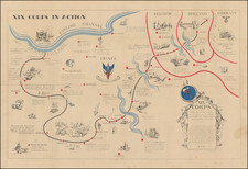
"Hitler's Crimes in Poland, Produced by Poland's Nazi-Hunting Commission." Rare Wall Map Edition.
Chilling map of the Holocaust, documenting the World War II extermination camps located on Polish soil. This map is notable both for being one of the earliest disseminated maps to trace the atrocities of the war on such a detailed scale, and also for being published in a nation and under a regime with biased views of the occupation. This map was commissioned by the Główna Komisja Ścigania Zbrodni przeciwko Narodowi Polskiemu, the Chief Commission for the Prosecution of Crimes against the Polish Nation, and this edition was published in 1971.
The map shows hundreds, if not thousands, of concentration camps, internment camps, prisoner of war camps, sites of razed villages, and mass execution sites, differentiating between each. The map notes that it would be impossible to mark all the places in which war crimes occurred. As such, this map, showing thousands of localities, denotes only the location of ten percent of camps and execution sites where more than fifty people were killed.
This map is incredibly important for representing Polish information-gathering regarding the Holocaust and Nazi atrocities while still under Soviet rule. The map was produced as a simple, stark piece based on research compiled by the Komisja and published as part of a remembrance exercise, with the double goal of educating the populace about the atrocities and garnering public support for prosecutions against war criminals.
The map reflects research conducted in the 1960s and '70s that was critical to preserving knowledge of the Holocaust. Prior to this period, heavy censorship and economic deprivation prevented the study of these issues, and the 1980s were again a recessive period, meaning that 1971 was in the middle of the golden years for war-crime research in Poland.
This map was based on information collected by Stefan Guirardm, Janusz Gumkowski, and Kazimierz Leszczynski. Janusz Gumkowski was a prominent Polish Jewish lawyer and historian, who was director for the main commission regarding the investigation of Nazi crimes in Poland. The editor was Jan Laskowski, a prominent cartographer, World War II veteran, and member of the Komisja who dedicated his life to studying war crimes.
Many of these larger maps were used in schools throughout Poland to educate students regarding the German occupation.
Polish Reinterpretations of the Holocaust
Studying the effects of German occupation in Poland is a delicate subject. While it is certain that Poland suffered at least as badly as any other European nation during the Second World War, reinterpretations of the Holocaust in the country have also been used to satisfy nationalistic tendencies. It has become evident to western observers in the last several years that there is a strong nationalist movement in Poland that seeks to place blame for the Holocaust solely on the shoulders of non-Polish actors, a movement originally fostered under Soviet rule. This movement has gone so far as to limit freedom of speech, criminalizing (with a three-year sentence) the suggestion that Poland or its citizens (in any form) participated in the murders committed by Nazis. As such, the term "Polish concentration camps" has been deemed unacceptable, with the government-approved term being "concentration camps on Polish territory."
All lines of evidence show that this map was produced using the most accurate and impartial historical sources. The language on the map is simple, naming only "Hitler's Atrocities," and there is no evidence of a clear anti-German bias. However, it is impossible to separate this map, one of the most important productions of the remembrance movement during this period, from the social situation in which it was produced. Maps like these can easily be converted into propaganda instruments, and today's Polish leaders, most of whom grew up during Soviet occupation, will have formed their understanding of the Holocaust through maps like these.
Soviet Censorship
While the content of the map appears to have been produced free from bias, the map still had to go through Soviet censorship. Mentioning prisoner of war camps, in which primarily Soviet troops were interned, would have been a prerequisite condition upon which the publication of the map rested. Further, the lack of mention of any Soviet killings or camps requires no explanation.
The map, unlike many later maps, makes no differentiation between the populations who suffered at the various camps. This represents the Soviet agenda that all nations suffered, fought, and won equally, which sought to limit divisions in this post-identity state.
Editions
This map was published several times, with issues identified from 1962 and 1968. The 1968 edition was prepared for the "Declaration on the Non-Applicability of Statutory Limitation to War Crimes and Crimes Against Humanity" in New York that year. This is the first known edition to include English-language text description at the bottom in red, describing the atrocities in detailed prose. At least two 1971 editions were produced, with a smaller edition also produced.
Rarity
The map is rare. WorldCat shows 4 examples of this 1971 map, one in Jewish National Library, one Staatsbibliothek zu Berlin, and 2 in Polish libraries. It is unclear how many of these are the reduced version.
![[ Baltic, Poland, Ukraine, Russia ] Tabula VIII Europe (title on verso)](https://storage.googleapis.com/raremaps/img/small/50926.jpg)
![[ Silesia / Southwestern Poland ] Schleisien in nieder-und ober Schlesien, ndann in Furtenthumer eingethelt, nebt der Grafschafte Glatz](https://storage.googleapis.com/raremaps/img/small/102990.jpg)