|
||

|

|
|

|
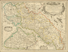
Important Six-Sheet German Military Map Prepared in the Lead-Up to the Invasion of Poland.
Very detailed six-sheet map covering the Poland-Germany frontier between the Baltic and roughly Racibórz published by the RfL (the central surveying office of the German Reich) in September 1938, one year before the invasion of Poland.
The focus of the map is on the river crossings and related infrastructure on the western Polish frontier with Germany. The key elaborates over a dozen symbols for bridges (rail, small gauge rail, road bridges of different capacities, etc.), ferries, canal overpasses, etc.
While making no mention of its intended use case, the map is clearly an invasion map of Poland, containing, as it does, all the necessary information for the logistical planning and execution of Germany's nascent blitzkrieg. In September of 1938 a planned German invasion of Poland was an incredibly sensitive issue, and the secret markings on all the sheets reflect this:
Geheim!
Dies ist ein geheimer Gegenstand im Sinne des § 88 Reichs-Straf-Gesetzbuchs (Fassung vom 24. April 1934). Missbrauch wird nach den Bestimmungen dieses Gesetzes bestraft, sofern nicht andere Strafbestimmungenin Frage kommen.
[Secret!
This is a secret item within the meaning of Section 88 of the Reich Criminal Code (version of April 24, 1934). Abuse will be punished according to the provisions of this law unless other penal provisions apply.]
Rarity
The map set is surprisingly rare given their relevance to our understanding of German war preparations leading up to 1939.
We did not locate a digitized example online. There is a mention of a set in the Bundesarchiv through the Deutsche Digitale Bibliothek.
OCLC locates no examples.
![[Napoleon]. A Sketch of the Russian Campaign in 1812](https://storage.googleapis.com/raremaps/img/small/63426.jpg)