|
||

|

|
|

|
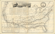
Scarce map of the United States, published by Cowperthwait, Desilver & Butler.
This is the second edition of Cowperthwait, Desilver & Butler's map of the United States and the first to show the lands acquired in the Gadsden Purchase.
The map shows some of the most unusual US territorial configurations. Oregon Territory and Washington Territory run from the Pacific Ocean to the Rocky Mountains, immediately after the creation of Washington Territory. Large New Mexico and Utah Territories appear for the first time, having just been established as territories in 1850.
A strange notch incorporates Middle Park in Colorado into Utah. Massive Nebraska Territory extends to Canada and the Rocky Mountains, just north of the oversized Kansas Territory. Texas is filled with early roads, including the road from Ft. Smith to Dona Ana made by General Arbuckle.
The Great Spanish Trail to Salt Lake is shown, as is Fremont's route. Lewis & Clark's route is noted. Many Indian tribes and early western forts. Large inset of the gold region in the year following the discovery of gold in California.
![A Map of North America, Constructed According To The Latest Information: by H.S. Tanner. Improved to 1825 [Case Map]](https://storage.googleapis.com/raremaps/img/small/68580.jpg)
![Map of the United States And Territories, Together with Canada &c. [Shows Massive Idaho Territory]](https://storage.googleapis.com/raremaps/img/small/100353.jpg)