|
||

|

|
|

|
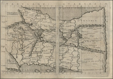
Scarce map of Northern Iran, western Afghanistan and southwestern Turkmenistan, published by the Royal Geographical Society.
Large folding map, extending from Tehran, Esfahan and the Caspian Sea in the west to Bukara (Uzbekistan) and western Afghanistan in the east, illustrating the paper of Colonel Stewart, entitled The Country of the Tekke Turkomans, and the Tejend and Murghab Rivers, presented on June 27, 1881.
The map provides a fantastic look at the roads in the region at the end of the 19th Century, along with the Caravanserai, wells, springs and other water sources in the region.
In the northwest, 24 miles of completed railway is shown, extending from Mikhailovsk toward Kizil Arvat.
Stuart visited the region disguised as an Armenian horse-dealer from Calcutta and was able to gain valuable insite into the geography, topography and hydrology of the region.
![[ Black Sea ] The Euxine or Black Sea From The Russian Survey of 1826](https://storage.googleapis.com/raremaps/img/small/99954.jpg)