


|
||

|

|
|

|
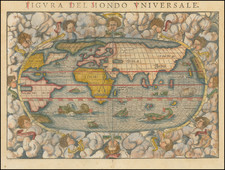
Very Rare First State of Van Den Keere’s World Map – With Lengthy Handwritten Descrition of the Voyages of Francis Drake on Verso
Fine and very rare example of Pieter van den Keere's decorative map of the world, issued in 1608. The map is considered to be one of the supreme examples of the Golden Age of Dutch Baroque cartography. This particular example also carries manuscript annotation on the recto and verso in a seventeenth-century hand.
The map is skillfully derived from Willem Janszoon Blaeu's double-page world map of 1608, but, through van den Keere's extensive annotations, the present map includes far more information about potential discoveries in the Arctic, Antarctic, and Australia.
Cartographically, the map's lineage can be traced through the Blaeu image to Petrus Plancius's wall map of 1592. The map incorporates some of the classic cartographic hypotheses of the period, including an elongated Northwest Coast of America, a massive mysterious southern continent (Antarctica) with a very narrow strait between it and South America, as well as an incomplete New Guinea that is attached to the southern continent.
The map features a lengthy notation to the left and right of the large cartouche titled 'America' that discusses whether in fact the apocryphal Anian Straits (at the location of modern-day Alaska) and the Davis Straits actually join to form the Northwest Passage. Related to this aspect, a sprinkling of English names in the Canadian Arctic is included as a result of Martin Frobisher and John Davis's explorations in search of the Northwest Passage in 1576-1587.
Notable improvements to Plancius' map include the discoveries of the voyages of Willem Barents (1594-1597) in the Russian Arctic, namely the correct depiction of Novaya Zemlya as an island, with an open sea lying between it and the North Pole. Both the Arctic and Antarctic Circles are detailed in insets towards the lower corners of the map.
The map was originally issued in 1608. The Le Maire Straits that run to the east of the Tierra del Fuego, discovered by Jacob Le Maire and Willem Schouten in 1616, were added to the plate around 1621. Thereafter, the plate was sold to Jan Jansson, who used the map in only a few early editions of his atlas. Eventually, the map was heavily reworked and reissued by Moses Pitt in the 1680s. This, however, is a rare first state.
Differences between the present map and Blaeu's 1606 world map
Despite its initial resemblance, the present map has significant differences when compared to Blaeu's 1606 map. These are largely confined to captions in the Arctic and on Terra Australis, but those textual choices provide important insight into van den Keere's editorial outlook. In general, the additions evidence van den Keere's stronger focus on recent and potential exploration at the edges of the world. Where Blaeu left blank areas, van den Keere has compiled notes from other sources to explain what might exist in these unmapped locations. These include rumors from Spanish and Portuguese sources (in the Pacific), as well as more detailed notes on English and Dutch exploration in the Arctic.
Additions and differences include:
In the vicinity of present-day Australia, van den Keere has added, “Maletur regnum scatens aromatibus” [A kingdom overflowing with spices]. Maletur, and the nearby Beach and Lucach are toponyms in Marco Polo’s Travels. However, its re-inclusion on this map raises the possibility that van den Keere was reacting to news of Willem Janszoon's 1605-06 voyage to Australia.
Notes on Terra Australis more generally (from left to right):
Hanc continentem Australem nonulli Magellanicam regionem abeius inventore nuncupant.
Hae regiones cuidam Hispano apparuerunt, cum disiectus a classe in hoc Australi vagaretur Oceano.
Psittacorum regio sic a Lusitanis appellate ob incredibilem earum avium ibidem magnitudinem.
Promontorium Terrae Australis distans 450 Lucas a Capite Bone Spei & 600 a promontorio S. Augustini.
Inter S. Laurenty & Los Romeros insulas vehemens admodum est versus ortum et occasum fluxus et refluxus maris.
To the east of Tierra del Fuego:
Navigium ex corijs quo accolae Freti Magellanici utuntur. [Borrowed from Jodocus Hondius's 1606 map of the Americas.]
In the Arctic (from left to right):
Anian Fretum et Fretum Joannis Davis latitudine 60. grad. e region insularum Orcadum, forte unu et idem est; plurimi enim multis argumentis contendu oram litoralem Americae Boream versus eousque protendi donec, in modum insulae cum terra Laboratorjs aut Groenlandiae coniungatur. Quad an verum sit saepius, sed frustra, quaesitum est proper ventorum asperos et impetuo sas turbines et maris fremitus terrificos, moutes glacie concretos planeque horendos.
Ulterius Septentrionem versus America omnio est incognita sitne aqua vel terra hoc loco incertum est plurimi tam ex rerum cicumstantiis, comjectant Americam ab hac parte Septentrionali mari succinctam.
Fretum hoc Davis, ab inventore Anglo nomen habet qui an. 1585. 86. et 87. hujus littora perlegit transitum illac in Chinam Scrutando.
Terram hanc e regione Finmarchiae 72 grad. positam detexit Hugo Willoughbeus Eques Anglus anno 1553.
Terra haec abe inventore Anglo nomen sortita est S, Hugo Willoughbes lant.
Nova Zemla Iustrati caepit faeliciter an. 1594. et 95. nominee Illustriss Ordinum foederatarum Infer. Germaniae Regionum, quo aditus ad Chinam Reg. quaerebatur: sed eventus nondum ex animi sententia votis successit.
Incertus admodum est hic Septentrionalis Asiae tractus nos tamen alios imitantes posuim ne imperitiores hic aliquid deesse putarent: donce certius quoddam exedt.
In western North America:
Harum Regionum Indiginae more Tartarorum catervatim in tentoriis habitant, civitates nullas habentes. [In the manner of the Tartars, these indigenous peoples dwell in battalions in tents, having no states.]
Decorative elements
The map includes van den Keere's signature symbol (a clock with a skull at the center, surrounded by flames), and his Flemish motto ("Wie gaat ick keere", i.e., "Many go, I shall return").
The panels that run along all sides of the map are rich with allegorical adornment. Across the top are vignettes of the known solar system, including:
- Luna (the Moon)
- Mercurius (Mercury)
- Venus, Sol (the Sun)
- Mars
- Jupiter
- Saturnus (Saturn)
The panel to the left depicts the four earthly elements:
- Igis (Fire)
- Aer (Air)
- Aqua (Water)
- Terra (Land)
The panel to the right of the map depicts the four seasons:
- Ver (Spring),
- Aestus (Summer)
- Autumnus (Fall)
- Hyems (Winter)
The panel that runs along the bottom of the map features the Seven Ancient Wonders of the World;
- Murus Babyloniae (The Hanging Gardens of Babylon, Nineveh, Iraq),
- Colossus (Colossus of Rhodes, Greece),
- Pyramides (the Great Pyramids of Gizeh, Egypt),
- Mausoleum (Mausoleum of Halicarnassus, Bodrum, Turkey),
- Dianae Templum (Temple of Diana, or Athena, Izmir, Turkey),
- Jupiter Olympicus (State Statue of Jupiter, or Zeus, Olympia, Greece)
- Pharos (The Great Lighthouse of Alexandria, Egypt).
Clarification of some claims by Shirley
Rodney Shirley (map 264) states:
This map, signed by Pieter van den Keere using an abbreviation of his latinised name Petrus Kaerius and dated 1608, is an undisguised and skilful copy of Willem Blaeu's single-sheet world map of two years earlier. The clarity and precision of Keere's engraving is in no way inferior to that of Josua van den Ende who engraved Blaeu's map. The interesting and detailed border decorations are identical to those of Blaeu and consist of the seven planets along the top, the seven wonders of the world along the bottom, and the four elements and the four seasons flanking the map to the left and right. The map itself has on it more legends than that of Blaeu, the principal additions referring to explorations in the Arctic. A long note near the cartouche headed 'America' queries whether the straits of Anian and Davis -do in fact link up to form a north-west passage. Keere's map, unlike the later states of Blaeu's, has strong rhumb lines radiating from three compass roses. It is slightly smaller because the outer beaded frame has been omitted. Apart from his Germania Inferior, Keere's attempts to produce an atlas were unsuccessful. He disposed of his stock of map plates to Jan Jansson in the early 1620s. Before this time however, his world map was amended to include Le Maire's strait, while still bearing Keere's signature and the date 1608. In 1621 Jan Jansson re-issued the map in its third state over his own signature Amstelodami Excudebat Johannes Janssonius, Anno 1621. In addition, Keuning (Imago Mundi XV, 1960, p. 69) notes that Keere's map may appear with the date 1622 in the Atlas published by Jean Le Clerc's widow. Later the date was erased, and copies of the fourth state are to be found in the rare Atlantis Maioris Appendix by Jansson and Hondius of 1630 and 1631, and occasionally in later atlases by the partnership and its successors up to 1675. Examples of the first three states are rare, and even the fourth state is uncommon. Finally, in 1680 the plate was resurrected and much amended by Jansson's heirs and two Englishmen, Moses Pitt and Steven Swart, in an ill-fated project to produce a twelve-volume atlas.
Shirley's census notes a single example of the first state at the BnF (Ge.D.12263), lacking the decorative borders. This could be interpreted to mean that the first state should not have decorative borders. This is incorrect; the BnF example simply had the borders masked or cut away. Schilder confirms this in MCN VIII (Keere 13.1).
Additionally, Shirley claims that the 1622 Van Den Keere world map is based on the present map. This is categorically untrue; the cartography, format, and decorative elements of that map bear no direct relationship to those seen on this map.
The manuscript annotations
The present example includes early ink annotations on the recto and verso. On the recto, the additions add in missing latitude degrees and add the star signs which correspond with each season in the decorative border to the right. They also label the elements in the top and bottom borders, the planets (“VII Planetæ”) and the Seven Wonders (“VII Miracula Mundi”).
On the map itself, the annotator has added in a sighting of land near Tierra del Fuego, at 45° S, most likely a reference to land supposedly seen by Francis Drake on his circumnavigation. Running along the bottom of the map are a series of sentences that, though faded, appear to explain the use of a world map as a geographic tool.
The notes are more extensive on the verso. They recount, now in French instead of Latin, the circumnavigation of Francis Drake (1577-1580). The writer is careful to emphasize Drake’s encounter with what the Englishman called New Albion, in what is today California. The so-called discovery gave England a claim to land on the west coast of North America, a claim that was hotly contested by the Spanish.
Rarity
Schilder records six examples of the first state: Budapest, Széchényi National Library (T 10017); Hamburg, Staats- und Universitätsbibliothek (KS 189/901 [7]), Leiden, Universiteitsbibliotheek (009-15-018); Paris, Bibliothèque nationale de France (Ge D 12263; lacking the decorative borders); French private collection; Australian private collection.
The present example was not recorded in Schilder's census.
The first state of the map is extremely rare on the market. While OldMaps.com lists some two dozen examples of the map having traded in the last thirty years, not one of these is the first state.
For a comparable market result, the first state of van den Keere's 1622 world map sold at Sotheby's in 2014 for over $35,000. (Note that while Sotheby's describes it as the second state, it is, in fact, the first.)
![Opusculum Geographicum Rarum [with map:] Universalis Orbis Descriptio, Cogimur e Tabula Pictos Ediscere Mundos.](https://storage.googleapis.com/raremaps/img/small/95970.jpg)

![(World) ЗАПАДНОЕ ПОЛУШАРИЕ | ВОСТОЧНОЕ ПОЛУШАРИЕ [Western Hemisphere | Eastern Hemisphere]](https://storage.googleapis.com/raremaps/img/small/90264.jpg)