|
||

|

|
|

|
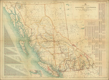
Important Early Map of the Province of British Columbia -- Updated To Show Early Post Offices
Nice example of this reduced sized version of the first map of the Province of British Columbia, produced by its most important early mapmaker and Lieutenant Governor and and colored to show the election districts for the first elections in the province.
First published in 1871, Trutch's map is the first map of the new province, an exceptionally detailed summary of the geographical knowledge of the region in 1871. Trutch draws upon the work of John Palliser (1857-61) and numerous surveys in the 1860s by British Royal Engineers, following its becoming a colony in 1858. The Cariboo goldfields are shown, incorporating the results of one of Canada's earliest gold rush, which compelled the creation of some of the earliest infrastructure and roads in the interior of the region. The coastal and hydrographical details along the coast are drawn from British Admiralty surveys, most notably those of Captain George Henry Richards, (1858-1859). The map would remain the baseline map and gold standard for the mapping of the region for several decades.
The present example meticulously adds numerous post offices which were not shown in the original 1871 edition.
Joseph William Trutch
Sir Joseph William Trutch was an English-born Canadian engineer, surveyor and politician. Trutch worked together with British Columbia's colonial governor, Anthony Musgrave to lay the foundation for its entry into the recently created Canadian Confederation, which was first created in 1867. In 1870, Trutch was part of the delegation which negotiated the terms of union with the Canadian Confederation and a promise ,for the construction of the Canadian Pacific Railway (CPR). While in London, he also contracted with Edward Standford to print 500 copies of his map of British Columbia (known as the 1871 Trutch Map).
Trutch was the first Lieutenant Governor of British Columbia following Confederation, a position he retained from 1871-1876. Following his tenure as lieutenant governor, Trutch was appointed a "Dominion agent for British Columbia", and helped to oversee the construction of the CPR in the province.
On July 20, 1871, British Columbia became the sixth province to join Canada. In return for entering the Confederation, Canada absorbed British Columbia's debts and committed to the construction of a rail route from Montreal to the Pacific Ocean within a decade, thereby bringing to a close a period of uncertainty in which the residents of British Columbia also debated joining the United States or remaining a British Colony separate from Canada.
The last spike of the Canadian Pacific Railway would not be driven until 1886, but its completion would ultimately result in a boom in the population of British Columbia that soon saw it become Canada's largest province.
![Map of Oregon Territory. By Samuel Parker. 1838. [with:] Journal of an Exploring Tour Beyond the Rocky Mountains, under the direction of the A. B. C. F. M. 1840.](https://storage.googleapis.com/raremaps/img/small/97939.jpg)
![[Havana / Cartagena] Neu und Verbesserter Plan der St. u. Hafens Havana aus der Ins. Cuba . . . 1739 [with] Neu under verbesserter lan des Hafnes non Cathaagena in America . . . 1740](https://storage.googleapis.com/raremaps/img/small/89441.jpg)