|
||

|

|
|

|
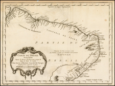
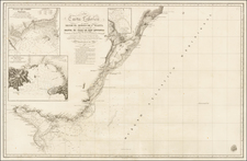
Fine original antique map of the island of Ilhamba, near Sao Paolo, published by Nicolas Bellin in 1764. This map originally appeared in Bellin's Petit Atlas Maritime, one of the most useful navigational handbooks published in the 17th century.
The map shows the island now referred to as Ilhabela (beautiful island) as being named Saint Sebastian. While the island has now changed its name, the mainland village across the bay is now known as Sao Sebastiao. Some of the unpopulated islands shown include the Ilha de Buzios and the Ilha Montao de Trigo. Other detail on the map includes depth soundings, anchorage points, and reckoning lines.
During the Brazilian colonial period, when this map was made, sugar cane was being grown on the island and nearby Sao Sebastiao was a center of gold exportation. The name of the island was changed in the earliest 19th century to reflect its prosperity and beautiful surroundings.
Jacques-Nicolas Bellin (1703-1772) was among the most important mapmakers of the eighteenth century. In 1721, at only the age of 18, he was appointed Hydrographer to the French Navy. In August 1741, he became the first Ingénieur de la Marine of the Dépôt des cartes et plans de la Marine (the French Hydrographic Office) and was named Official Hydrographer of the French King.
During his term as Official Hydrographer, the Dépôt was the one of the most active centers for the production of sea charts and maps in Europe. Their output included a folio-format sea atlas of France, the Neptune Francois. He also produced a number of sea atlases of the world, including the Atlas Maritime and the Hydrographie Francaise. These gained fame and distinction all over Europe and were republished throughout the eighteenth and even in the nineteenth century.
Bellin also produced smaller format maps such as the 1764 Petit Atlas Maritime, containing 580 finely-detailed charts. He also contributed a number of maps for the 15-volume Histoire Generale des Voyages of Antoine François Prévost.
Bellin set a very high standard of workmanship and accuracy, cementing France's leading role in European cartography and geography during this period. Many of his maps were copied by other mapmakers across the continent.
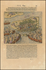
![[ Porto Calvo ] Eroberung der Vestung Povacon zu Porto Calvo in Brasilia, durch Graff Joh. Mauritz van Nassau General in Brasilien, im Febuario und Mario Anno 1637 . . .](https://storage.googleapis.com/raremaps/img/small/0325gh.jpg)