|
||

|

|
|

|
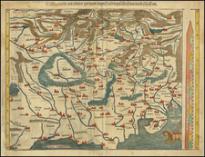
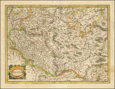
Finely colored example of Gerard de Jode's map of the Holy Roman Empire, engraved by Johannes van Deutecum and Lucas van Deutecum.
Published in De Jode's rare first atlas of 1578, the map was originally drawn from a map produced in 1542 as part of a collaboration between Heinrich Zell and Nicolaus Copernicus.
The map is drawn from a separately published map of the same region, first issued by Gerard De Jode in 1562, which in turn was based on a map designed by Heinrich Zell and published in Strasbourg in 1560, based upon an original map of 1542. The map highlights at its center the Kingdom of Bohemia, the favored location of Rudolf II, who had become Holy Roman Emperor in 1576, although the court would not be moved to Prague until 1583.
This is the second state of 2, with the privilege added, Johannes van Deutecum's surname changed to "dutecum" and designation "Suidbevelant" added.
Heinrich Zell
Heinrich Zell was a German printer and mapmaker, and a student of Sebastian Münster. In collaboration with Nicolaus Copernicus, Zell produced the first geostatic map of the Prussian coastline and the first map of Prussia, drawn in 1542. Zell incorporated Ermland (Warmia) records of Prussian towns in this detailed and until then unaccomplished task.
De Jode's Speculum Orbis Terrarum
One of the great rarities of sixteenth-century mapmaking, the De Jode family's Speculum Orbis Terrarum represents over twenty-five years of work shared between two generations. The work was published in two editions, first by Gerard de Jode in 1578 and then in an expanded edition by his son, Cornelis, in 1593.
The Speculum is the second general atlas of the world, after Ortelius' Theatrum Orbis Terrarum. In Antwerp, in 1570, Ortelius published the first modern atlas; that is, a set of uniform maps with supporting text gathered in book form. Previously, there were other bound map collections, specifically, the Italian Lafreri atlases, but these were sets of maps—not necessarily uniform—selected and bound together on demand.
The first edition of Gerard De Jode’s atlas was published in Antwerp in 1578. Gerard De Jode (1509-1591) released his atlas in a golden age of Dutch atlas production: Ortelius’ atlas was released in 1570, also in Antwerp; the first town atlas was in 1572, the first pocket atlas in 1577, the first regional atlas in 1579, the first nautical atlas in 1584, and the first historical atlas in 1595. De Jode’s atlas was intended as competition for Ortelius’. Mercator was also preparing an atlas at the time, and corresponded with Ortelius, but it would not appear in full until 1595, a year after Mercator’s death.
Although the Speculum was ready as early as 1573, it was not published until 1578. This is most likely due to Ortelius’ influence and his privilege over atlas production, which expired just before De Jode finally published. The atlas was the result of collaboration between De Jode, the geographer Jan van Schille of Antwerp, German physician Daniel Cellarius, and the etchers Joannes and Lucas van Doetecum.
Although never as successful as Ortelius’ Theatrum, the Speculum did get republished in a second edition in 1593, two years after De Jode’s death, by Arnold Coninx. After his death, Gerard’s son, Cornelis (1568-1600), and his wife, Paschina, then ran the shop. Unfortunately, Cornelis died young in 1600, aged only 32, and the stock and plates were sold to the publisher Joan Baptista Vrients. Vrients had also recently purchased the plates for Theatrum, giving him a monopoly over Antwerp atlas publication. Vrients acquired the De Jode atlas plates only to suppress them in favor of the Ortelius plates, thus the De Jode atlas maps are quite rare on the market today.
Scholarly and historical comparison between the Speculum and the Theatrum varies. The great cartographers of the late sixteenth- and early seveneenth-centuries, including Montanus, van den Keere, and von Aitzing, used both as sources, and Hondius compared the former work favorably against the latter. Later scholarly review notes less consistency in the cartography in de Jode's work, particularly in some of the Germanic regions, although the craftsmanship of the engraving is highly praised.
Gerard De Jode (1509-1591) was a pre-eminent mapmaker in the late seventeenth century, a time when the Dutch dominated the map trade. He was known for his many maps, some of which featured in Speculum Orbis Terrae (first edition Antwerp: 1578). Although never as successful as Ortelius’ Theatrum, the Speculum did get republished in a second edition in 1593, two years after De Jode’s death, by Arnold Coninx, and included this map. After his death, Gerard’s son, Cornelis (1568-1600), and his wife, Paschina, ran the shop. Unfortunately, Cornelis died young in 1600, aged only 32, and the stock and plates were sold to the publisher Joan Baptista Vrients.