


|
||

|

|
|

|
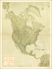
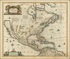
The Hondius / Jansson’s Map of North America, A Map Central to the Myth of California as an Island
Striking example of the second state of Henricus Hondius’ and Jan Jansson’s map of North America, called by Burden the single most influential map in perpetuating the myth of California as an island to that date. It is also the first atlas map to focus exclusively on North America.
Although California is a prominent feature, it certainly is not the only interesting aspect of this map. A Rio del Norto flows from a large lake in the interior. In South America, another lake, Parime lacus is also shown, a reference to the El Dorado myth. On the eastern seaboard of North America, one can spot Iames Towne, the still small English settlement.
The map is a well-researched amalgam of the best cartographic resources available at the time. It first debuted in 1636; this is a second state with the signature of Joannes Janssonius [Jan Jansson] included in the lower-left cartouche. For the western area, the Hondius house mapmakers drew upon Henry Briggs’ The North Part of AMERICA (1625). For the Gulf of Mexico and Florida, there are many similarities to Hessel Gerrtisz’s ca. 1631 chart. Some of the place names from John Smith’s map of Virginia are included, but the east coast north of Florida seems to be largely an original composition. The Gulf of St. Lawrence follows the work of De Laet and, to the north, the recent work by Thomas James (1633) is borrowed for the west coast of Hudson’s Bay.
In addition to the latest depiction of geographic features, the map features many decorative elements. Animals, including a polar bear, a fox, a boar, bison, and others roam the open North American interior. Ships and sea monsters dot the waters, including north of the island of California—a sly reference to the possible geography of that unmarked coast. The northwest coast is further obscured by a large title cartouche showing indigenous Americans in full battle dress flanking an ornate frame topped with various reptiles. In the lower-left is another cartouche, this one with swimming putti using navigational equipment and staring at a globe. This second cartouche also contains Jansson’s name in this, the second state of the map.
States and publication
As previously stated, this is the second state of the map. The first was made in 1636 by Henricus Hondius; it is distinguished from this because the cartouche in the bottom left is blank as opposed to containing the name of Jan Jansson. This second state appeared in 1641. The third state was a reissue by Petrus Schenk; it bears his imprint and has dotted lines demarcating regions. The map was issued as part of the Atlas Novus, Hondius and Jansson’s highly successful atlas. This is an essential map for collectors of North America and California.
- Lower-left cartouche is blank, Henricus Hondius, 1636
- Lower-left cartouche reads "Amstelodami, Excudit Ioannes Ianssonius", 1641
The popular misconception of California as an island can be found on European maps from the sixteenth through the eighteenth centuries. From its first portrayal on a printed map by Diego Gutiérrez, in 1562, California was shown as part of North America by mapmakers, including Gerardus Mercator and Abraham Ortelius. In the 1620s, however, it began to appear as an island in several sources. While most of these show the equivalent of the modern state of California separated from the continent, others, like a manuscript chart by Joao Teixeira Albernaz I (ca. 1632) now in the collection of the National Library of Brasil shows the entire western half of North Americas as an island.
The myth of California as an island was most likely the result of the travel account of Sebastian Vizcaino, who had been sent north up the shore of California in 1602. A Carmelite friar, Fray Antonio de la Ascensión, accompanied him. Ascension described the land as an island and around 1620 sketched maps to that effect. Normally, this information would have been reviewed and locked in the Spanish repository, the Casa de la Contratación. However, the manuscript maps were intercepted in the Atlantic by the Dutch, who took them to Amsterdam where they began to circulate. Ascensión also published descriptions of the insular geography in Juan Torquemada’s Monarquia Indiana (1613) (with the island details curtailed somewhat) and in his own Relación breve of ca. 1620.
The first known maps to show California as an island were on the title pages of Antonio de Herrera’s Descripción de las Indias Occidentales (1622) and Jacob le Maire's Spieghel Der Australische Navigatie (1622). Two early examples of larger maps are those by Abraham Goos (1624) and another by Henry Briggs, which was included in Samuel Purchas’ Hakluytus Posthumus or Purchas his Pilgrimes (1625). In addition to Briggs and Goos, prominent practitioners like Jan Jansson and Nicolas Sanson adopted the new island and the practice became commonplace. John Speed’s map (1626-7), based on Briggs’ work, is well known for being one of the first to depict an insular California.
The island of California became a fixture on mid- and late-seventeenth century maps. The island suggested possible links to the Northwest Passage, with rivers in the North American interior supposedly connecting to the sea between California and the mainland. Furthermore, Francis Drake had landed in northern California on his circumnavigation (1577-80) and an insular California suggested that Spanish power in the area could be questioned.
Not everyone was convinced, however. Father Eusebio Kino, after extensive travels in what is now California, Arizona, and northern Mexico concluded that the island was actually a peninsula and published a map refuting the claim (Paris, 1705). Another skeptic was Guillaume De L’Isle. In 1700, De L’Isle discussed “whether California is an Island or a part of the continent” with J. D. Cassini; the letter was published in 1715. After reviewing all the literature available to him in Paris, De L’Isle concluded that the evidence supporting an insular California was not trustworthy. He also cited more recent explorations by the Jesuits (including Kino) that disproved the island theory. Later, in his map of 1722 (Carte d’Amerique dressee pour l’usage du Roy), De L’Isle would abandon the island theory entirely.
Despite Kino’s and De L’Isle’s work, California as an island remained common on maps until the mid-eighteenth century. De L’Isle’s son-in-law, Philippe Buache, for example, remained an adherent of the island depiction for some time. Another believer was Herman Moll, who reported that California was unequivocally an island, for he had had sailors in his offices that claimed to have circumnavigated it. In the face of such skepticism, the King of Spain, Ferdinand VII, had to issue a decree in 1747 proclaiming California to be a peninsula connected to North America; the geographic chimera, no matter how appealing, was not to be suffered any longer, although a few final maps were printed with the lingering island.
Henricus Hondius (1597-1651) was a Dutch engraver and mapmaker, a member of a prominent cartographic family. His father, Jodocus Hondius, was also an engraver and geographer. While working with his father, Henricus was instrumental in the expansion and republishing of Mercator’s atlas, first published in 1595 and republished by Hondius in 1606.
Upon his father’s death in 1612, Henricus and his brother, Jodocus the Younger, took over the business. He set up his own shop in 1621, where he continued to release new editions of the Mercator atlas. Later, he partnered with his brother-in-law, Jan Janssonius, in continuing to expand and publish Mercator’s atlas, which would become known as the Mercator-Hondius-Janssonius atlas. Born and based in Amsterdam, he died there in 1651.
Jan Janssonius (also known as Johann or Jan Jansson or Janszoon) (1588-1664) was a renowned geographer and publisher of the seventeenth century, when the Dutch dominated map publishing in Europe. Born in Arnhem, Jan was first exposed to the trade via his father, who was also a bookseller and publisher. In 1612, Jan married the daughter of Jodocus Hondius, who was also a prominent mapmaker and seller. Jonssonius’ first maps date from 1616.
In the 1630s, Janssonius worked with his brother-in-law, Henricus Hondius. Their most successful venture was to reissue the Mercator-Hondius atlas. Jodocus Hondius had acquired the plates to the Mercator atlas, first published in 1595, and added 36 additional maps. After Hondius died in 1612, Henricus took over publication; Janssonius joined the venture in 1633. Eventually, the atlas was renamed the Atlas Novus and then the Atlas Major, by which time it had expanded to eleven volumes. Janssonius is also well known for his volume of English county maps, published in 1646.
Janssonius died in Amsterdam in 1664. His son-in-law, Johannes van Waesbergen, took over his business. Eventually, many of Janssonius’ plates were sold to Gerard Valck and Pieter Schenk, who added their names and continued to reissue the maps.
![[ First Map to Name The United States ] L'Amerique septentrionale ou se remarquent les Etats Unis . . . 1779](https://storage.googleapis.com/raremaps/img/small/94192.jpg)