|
||

|

|
|

|
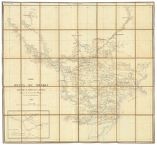
The First Large Format Map of French Cochinchina
Rare separately published map of the southern part of Vietnam and Cambodia centered on the Mekong Delta and River.
This map was published by French authorities in 1863, shortly after the 1858 capture of Saigon and the establishment of the first French colony in Vietnam, as well as the 1862 signing of the Treaty of Saigon, which formally ceded the territories.
The map extends from the coast and the area around Ho Chi Minh City (Saigon) to the area around Phenom Penh in Cambodia, with the Mekong Delta taking up a large portion of the map. The map focuses on the three provinces ruled by France at the time (collectively known as Cochincina): Biên Hòa (in red), Gia Định (in yellow) and Định Tường (in green).
This map was commissioned by the Emperor Napoleon III, and it can be noticed that the map extends into regions that were not yet in French control. French ambitions in the region were not satiated with the first three provinces occupied: in 1867, three more provinces (the southern three shown on the map) would be occupied and turned into colonies.
The map includes a number of additional details important to the colonial rule of Vietnam. At the base of the map, a chart shows the administrative divisions for the provinces shown on the map, and the lower right lists the former leaders and important figures in the colony who contributed to surveying and making the map.
French Cochinechina
While Cochinechina was a term long-used to describe the region around the South Vietnamese capital of Saigon, its importance increased as the first area colonized by the French in the region. Tensions in Vietnam had long simmered between French missionaries (who had been active since the 17th century) and the local ruling powers, and under the guise of protecting the missionaries, Napoleon III order gunships to attack a port city in 1858.
The next nine years were spent consolidating French Cochinechina. The first major success was the capture of Saigon in 1859, which the Vietnamese proceeded to siege for two years, believing they could retake the city. Peace terms were offered several times, before being accepted in the Treaty of Saigon in 1862. This formally passed control to France of the three Vietnamese provinces nearest to Saigon. In 1867, during continued insurgency, French troops occupied three more provinces. Control over the rest of the country for France would not come until the 1880s.
Rarity
The map is extremely rare. We locate a single example in the Bibliotheque National de France.
The Dépôt de la Marine, known more formally as the Dépôt des cartes et plans de la Marine, was the central charting institution of France. The centralization of hydrography in France began in earnest when Jean-Baptiste Colbert became First Minister of France in 1661. Under his watch, the first Royal School of Hydrography began operating, as did the first survey of France’s coasts (1670-1689). In 1680, Colbert consolidated various collections of charts and memoirs into a single assemblage, forming the core of sources for what would become the Dépôt.
The Dépôt itself began as the central deposit of charts for the French Navy. In 1720, the Navy consolidated its collection with those government materials covering the colonies, creating a single large repository of navigation. By 1737, the Dépôt was creating its own original charts and, from 1750, they participated in scientific expeditions to determine the accurate calculation of longitude.
In 1773, the Dépôt received a monopoly over the composition, production, and distribution of navigational materials, solidifying their place as the main producer of geographic knowledge in France. Dépôt-approved charts were distributed to official warehouses in port cities and sold by authorized merchants. The charts were of the highest quality, as many of France’s premier mapmakers worked at the Dépôt in the eighteenth century, including Philippe Bauche, Jacques-Nicolas Bellin, Rigobert Bonne, Jean Nicolas Buache, and Charles-François Beautemps-Beaupré.
The Dépôt continued to operate until 1886, when it became the Naval Hydrographic Service. In 1971, it changed names again, this time to the Naval and Oceanographic Service (SHOM). Although its name has changed, its purpose is largely the same, to provide high quality cartographic and scientific information to the France’s Navy and merchant marine.
![(Phuket) A Plan of the Isles of Merguy [with:] Plan of Junkseylon Island](https://storage.googleapis.com/raremaps/img/small/94799.jpg)