|
||

|

|
|

|
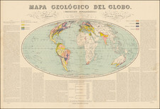
The 1946 Stose Geological Map of North America, being the third geological map of the continent published during the 20th century and the first published since 1911. Having been published after such a long hiatus, this map contains a plethora of new information while showing some of the biases of its progenitor. The map is here presented with only the lower of its two sheets, extending through nearly the whole of the United States, some of southern Canada, and through Mexico to the northern tip of South America.
This map filled in the remaining gaps that had been left in the Willis - Stose map of 1911, particularly in Alaska and the Canadian Northwest. In addition, significant resolution is added to various parts of the map, including Baja California. Several major mistakes percolate, including the dating of the Windward Isles as Cretaceous when they are significantly more recent than that.
In total on the map, ninety-one units are distinguished, but a 2005 review published by the Geological Society of America criticized the subdivision of units as too preferential towards Appalachian divisions, reflecting Stoses's background. This leads to a highly precise and detailed map, and, in all, a very interesting object.

![A New Map of North America Shewing its Principal Divisions, Chief Cities, Townes, Rivers, Mountains &c. Dedicated to His Highness William Duke of Gloucester [California as an Island]](https://storage.googleapis.com/raremaps/img/small/100578.jpg)