The item illustrated and described below is sold, but we
have another example in stock. To view the example which
is currently being offered for sale, click the
"View Details" button below.
1943 War Office
$ 475.00


|
||

|

|
|

|
Stock# 81010
Description
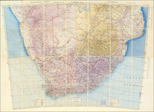
Fantastic World War II era navigation map of southern Africa, prepared by the British military for ground and air navigation in late 1943.
The map was compiled from four separate sheets cut and mounted together to form a larger image. The map covers parts or all of South West Africa, Bechuanaland Protectorate, South Africa, Basutoland, Swaziland, Rhodesia, and Mozambique.
Though far away from the front lines of World War II, southern Africa was of global geopolitical importance and required excellent maps, especially for newly emerging long-range airplane flights.
Condition Description
Segmented and laid on linen, as issued. Several paper elements onlaid, as issued. Original green cloth cover with label of George Philip & Son Ltd.
![[ First Modern Map of Southern Africa ] Tabula Moderna Secunde Porcionis Aphricae](https://storage.googleapis.com/raremaps/img/small/66800.jpg)

![[South Africa] Charte der Sudspize von Africa oder des Hottentotten und Caplands . . . 1806](https://storage.googleapis.com/raremaps/img/small/54869.jpg)
![[South African Republic, Orange Free State, Natal, Basutoland, etc.] The Absent-Minded Beggar](https://storage.googleapis.com/raremaps/img/small/78441.jpg)