


|
||

|

|
|

|
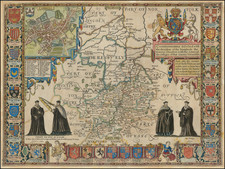
Rare Late State.
An attractive full-color example of Speed's map of Cambridge, from a late 18th-century edition of Speed's Theatre of Great Britain, first published in 1611. The map includes a large inset plan of Cambridge and 25 different coats of arms.
The map shows a Cambridgeshire more limited than in its present-day extent. The fens are sparsely populated, still labeled the Isle of Ely. These would be drained in the 1630s after the map was made. The Fyrth Dyke is shown, apparently in the place of the New Bedford River. The hills and forests to the south of Cambridge are drawn, including at Gogmagog though Coton is omitted. Cherry Hinton [Hynton], Chesterton, Girton, Grantchester, and Trumpington are all portrayed independent from Cambridge. The source of the Cam can be traced to Henxworth more easily than on modern maps. It joins first the Granta before Cambridge, then the Great Ouse between Cambridge and Oxford. Parts of Lincolnshire, Suffolk, Norfolk, Hertfordshire, Bedfordshire, and Huntingdonshire are all shown. Shows Toft.
An inset map of Cambridge is shown. The crest shown is of the city of Cambridge, designed in 1575 to represent both Cambridge Castle and the navigability of the River Cam. The layout of the Medieval part of the city has changed little since this map was created. Magdalene College is the only college with buildings west of the Cam. St. John's College's Second Court does not appear, though it predates this map by several years. All Saint's Garden is occupied by a church. Trinity's [Trinitie] Great Court is misshapen and the Paddocks are unvegetated, unlike the rest of the Backs. King's [Kinges] comprises little more than a chapel. Queen's has gardens where Cripps Court now stands. Pembroke [Pembrok] owns an Orchard, now Downing Site and Downing College. Emmanual backs onto what appear to be fields of wheat.
Crests related to the university and constituent colleges are shown along the sides of the map. A blank crest is drawn, perhaps left to be filled in as the number of constituent colleges grew. This was an unnecessary precaution as the map was published at the start of a two-hundred-year hiatus in the founding of colleges between the foundation of Sidney Sussex and Downing. The crest of Sigebert, King of the East Saxons and legendary founder of Cambridge, is shown and described as the coat of arms of the founder of the University. While his crest can be found around the present-day university and in literature, Bishop Balsham of Ely normally is accepted have founded the University. Coat of arms of various powerful figures are shown below the map: note the similarity between the recently founded colleges St. John's, Christ's and King's to those belonging to the House of York. In addition, the crest of the monarch of the United Kingdom is shown on the figure of a unicorn and eagle. This is nearly identical to the crest of St. John's College, and the motto "Dieu et mon Droit" is the motto of this college, and of Christ's College.
Images throughout the map portray scholars of the University. Academics in robes discuss texts to the right of the map and hold an oversized sextant to the left.
It is interesting to note that so much attention is paid to the University in a time that predates what it is known for in modern times. Overall, a very attractive and detailed map of Cambridge and Cambridgeshire.
John Speed (1551 or '52 - 28 July 1629) was the best known English mapmaker of the Stuart period. Speed came to mapmaking late in life, producing his first maps in the 1590s and entering the trade in earnest when he was almost 60 years old.
John Speed's fame, which continues to this day, lies with two atlases, The Theatre of the Empire of Great Britaine (first published 1612), and the Prospect of the Most Famous Parts of the World (1627). While The Theatre ... started as solely a county atlas, it grew into an impressive world atlas with the inclusion of the Prospect in 1627. The plates for the atlas passed through many hands in the 17th century, and the book finally reached its apotheosis in 1676 when it was published by Thomas Bassett and Richard Chiswell, with a number of important maps added for the first time.
![[London to Sheppey Island / Great Yarmouthand environs] Afteekening van de Rivier van London of River Thames / Afteekening van de Tarmouthse Banken geleegen voor Iarmouth Aan de Oost](https://storage.googleapis.com/raremaps/img/small/85128.jpg)
![[ Norwich ] Nordovicum Angliae Civitas](https://storage.googleapis.com/raremaps/img/small/96877.jpg)