|
||

|

|
|

|
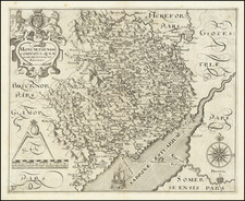
A handsome example of Christopher Saxton's map of Somerset, issued in London in 1579.
The map covers all of the County of Somerset as it was in the middle of the 16th century; dozens of small towns and hamlets are shown and labeled, hills and enclosures are rendered pictorially. Selwood forest is illustrated at the east side of the map.
Bristol is represented pictorially at the top of the map and is shown straddling the River Avon.
This is the second state (first non-proof state) of the map. It has the title engraved and the date reads "1575".
The title cartouche displays the royal coats of arms, in the lower right corner is the coat of arms of Thomas Seckford, Saxton's patron. Also included on the map are a scale bar, a sea monster, and several tall ships. This map was engraved by Leonardus Terwoort of Antwerp.
Saxton's Atlas of England and Wales
Saxton's Atlas is considered the cornerstone of English cartography, and it set the standard cartographic representation of Great Britain and its counties, and was reproduced countless times domestically and abroad. The use of maps developed in the mid-16th century in England as Elizabethan government agents needed them to inform their decisions. Authorized by the queen's privy council, Lord Burghley selected Christopher Saxton to produce a survey of the country, which would be financed by Thomas Seckford.
The atlas contained thirty-five maps, including a general map of the country and individual county maps as well. Maps were all designed by Saxton, and engraved by Dutch or Flemish artisans that Saxton employed. Maps from Saxton's Atlas are very rare.