|
||

|

|
|

|
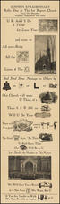
An Early Modern Interactive Astronomical and Geographical Primer
Fine, informative intellectual broadside with diagrams and instructions for geographic, astronomical, and gnomonic (the shadow cast by a sundial) measurements, possibly for the creation of a paper astrolabe.
The paper instrument templates on this sheet were meant to allow for a variety of calculations to be performed, forming a brief, but effective, textbook for an astute student. For example, the ruler-like figure at center allows for the measurement of antipodes. The various possible actions are explained with reference to lettered points around the sheet.
The diagram in the lower left allows for the calculation of time. That on the right is used to make observations on a celestial globe, which could be useful for navigation, astronomy, and geography. For example, the horizon is marked, showing how altitude measurements correspond to one’s position. One could also find the location of the sun in the ecliptic, and plot the positions of planets.
Paper instruments, while often overlooked today, were some of the most ubiquitous learning aids in the early modern period. While it seems antithetical (or heretical) to take a knife to a book or sheet of antique paper, it was common practice in this time for mathematical texts and other works to include pages meant to be cut up and assembled into pointers, volvelles, and dials. Diagrams could also be scored with a stylus or oiled to avoid their destruction and allow for reuse. Instrument books appeared from at least the 1550s and continued in use until the mid-eighteenth century.
Tobias Conrad Lotter (1717-1777) is one of the best-known German mapmakers of the eighteenth century. He engraved many of the maps published by Matthaus Seutter, to whose daughter Lotter was married. He took over Seutter’s business in 1756. Lotter’s son, M. A. Lotter, succeeded his father in the business.
![[Charles Lindbergh] Our Hero](https://storage.googleapis.com/raremaps/img/small/67612.jpg)