
This item has been sold, but you can enter your email address to be notified if another example becomes available.


|
||

|

|
|

|
Stock# 80984
Description
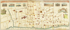
Fine original antique map published by John Strype in 1755 showing the region around the Church of St. James in Clerkenwell, which was, at the time, on the farthest reaches of London. This is a later state of a map first published in 1720.
The map is detailed, with individual buildings, gardens, roads, and more all shown. A reference in the lower left of the map labels 36 places of interest. The map includes a decorative cartouche and a simple compass rose.
![The Tower of London, As Seen October 31st 1841 [the morning after the fire]](https://storage.googleapis.com/raremaps/img/small/92003.jpg)
![[London] Redriffe and Part of St. Mary Magdalens Parish Southwark Taken from ye Latest Survey with Corrections](https://storage.googleapis.com/raremaps/img/small/70290.jpg)
![Londinum Urbs Praecipua Regni Angliae [London, the Principal City of the Kingdom of England.]](https://storage.googleapis.com/raremaps/img/small/93684.jpg)