|
||

|

|
|

|
Stock# 80980
Description
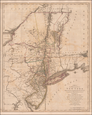
Detailed and interesting map of New York, published by HS Tanner.
The map is hand-colored by county and shows towns, rivers, bays, lakes, railroads, roads, mountains, forts, etc.
Tables of steamboat routes and distances and a profile of the Erie Canal.
Tanner's Universal Atlas was the forerunner of a series of American atlases continued by Mitchell; Thomas, Cowperthwait & Co.; Desilver; S.A. Mitchell Jr, and others which extended to the early 1890s.
This map was reissued with changes to the title block into the 1850s.
![[ Inhabitants of New Netherlands ] Einwohner in Neu Niederland](https://storage.googleapis.com/raremaps/img/small/94087.jpg)
![[Lake Champlain and environs] Carte de la Riviere de Richelieu et du Lac Champlain](https://storage.googleapis.com/raremaps/img/small/91308.jpg)