
This item has been sold, but you can enter your email address to be notified if another example becomes available.


|
||

|

|
|

|
Stock# 80951
Description
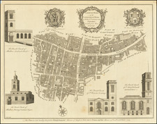
Fine, original, antique map of London as it stood during the Regency, showing fine, city block-level detail.
The map shows the West India Docks, the East India Docks, and other features in the Isle of Dogs and Canary Wharf. Southwark is developing further south, and Greenwich is shown. Westward, the map extends to Hyde Park, Regent's Park, Chelsea, and Kensington.
Below the map, an extensive listing of 350 streets in London is given. The map was published by Charles Smith on Surrey Street Stand in 1818.
Condition Description
Original hand color. Dissected in twenty-one segments and mounted on original publisher's linen. Minor soiling and toning.
![[ London ] Die Gegend um London](https://storage.googleapis.com/raremaps/img/small/103695.jpg)
![[ London ] An Exact Survey of the City's of London Westminster ye Borough of Southwark and the Country Near Ten Miles Round Begun In 1741 & Ended in 1745 By John Rocque Land Surveyor & Engrau'd By Richard Parr / A New and Accurate Survey Of the Cities of London and Westminster The Borough of Southwark with The Country about it for nineteen Miles in Length and thirteen in Depth . . .](https://storage.googleapis.com/raremaps/img/small/96431.jpg)