|
||

|

|
|

|
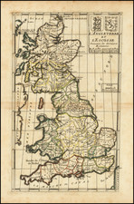
Edmund Halley’s Tide Chart of the English Channel—With Manuscript Additions!
Impressive chart of the English Channel, based on Edmund Halley’s pioneering third voyage in the Paramore.
This chart is especially important because it was the first to implement Halley’s Roman numeral system for marking tidal flow—a landmark in thematic mapping.
The present example is also special because it includes manuscript additions in a period hand. On the verso are “Directions for ye Low Streame,” a set of sailing directions to navigate along the south coast of England. Their inclusion shows the popularity and importance of Halley’s chart, which was in use throughout the first half of the eighteenth century.
The chart minutely shows the important channel between England and France. It includes a blanket of sounding depths, tide direction arrows, and rhumb lines. The “Advertisement” between Sussex and Kent explains the Roman numerals scattered in the waters. It explains:
The Smaller Figures in the Channell Draught Shew ye depths of Water in Fathoms and the Litterall or Roman Figures Shew ye houre of High Water or how long the Stream will runn to the Eastward on the day of the New & Full Moon therefore if you Add the time of ye Moons Southing or Northing to the Houre found near the place of your Shipp the Summ will Shew you how long the Tyde will runn to the Eastwards but if it exceed 12 Subtract 12 therefrom and the Remainder is the Houre.
The Advertisement ends with a plea for more information, so as to improve safety for all mariners with better charts.
The shores are crowded with the names of ports, towns, and harbors. The inland areas are filled with elaborate insets of Portsmouth Sound, the Isle of Wight, the Thames Estuary, and, in the top left corner, the Scilly Isles. Above the top border are a series of profiles of interesting promontories.
Halley’s voyages and his charts
Halley was a prolific publisher and his output included several important maps and charts, including his groundbreaking untitled world map of 1686 showing the trade winds. During the 1680s, Halley became increasingly concerned with the implications of magnetic variation for navigation. Not one to just read about a phenomenon, Halley sought command of a Royal Navy vessel, the Paramore, and took it on three voyages between 1698 and 1701. The first two, to the South Atlantic, were to study geomagnetism. The third, in the English Channel, focused on tidal phenomena. While his journals were not published during his lifetime, his charts from those voyages were.
The first chart he published was a chart of the Atlantic with isogonic lines, “A New and Correct Chart Shewing the Variations of the Compass in the Western & Southern Oceans as observed in ye year 1700 by his Ma/ties Command.” Dedicated to William III, who died on March 8, 1702, the chart is usually dated to 1701, as Halley returned from his second voyage on September 18, 1700. It was printed by Richard Mount and Thomas Page of Tower Hill and engraved by John Harris. He presented the chart to the Royal Society on June 4, 1701.
The chart of the world’s oceans which Halley created would prove more influential and grow to greater prominence, appearing in several states, foreign editions, and even updated revisions. It was the first printed world map to employ isogonic lines. That chart first appeared in 1702, datable by the dedication cartouche in Africa that references “Prince George of Denmark, Lord High Admiral.” The Prince Consort was elevated to that position on April 17, 1702.
Interestingly, although the world chart proved popular and was reissued, translated, and updated (see Montaine and Dodson’s chart (1744) which extends the isogonic lines to the Pacific), the chart became scarce in all iterations over time. Indeed, by 1870, Halley’s charts were so scarce that Sir George Airy, Astronomer Royal, exasperatedly exclaimed that, despite having seen references to “Halley’s Magnetic Chart,” he had “not ascertained that any writer had ever seen it…As I was desirous of making myself acquainted with a document so important in the history of magnetic science, I made enquiries in nearly every Academy in Europe, but could not find anywhere a copy of this Chart.” He eventually did find an example of the world chart nearby, at the British Library; he seems not to have known of the existence of the Atlantic chart.
The English Channel tidal chart: creation and publication
Halley’s most popular cartographic output was this chart of the tides in the English Channel, although examples of it various states are also now scarce. Halley returned from his third voyage on October 10, 1701 and immediately sought to prepare his findings. He wrote to Josiah Burchett, Secretary to the Admiralty, that he had, “discovered, beyond my expectation, the generall rule of the Tides in the Channell; and in many things corrected the Charts thereof” (TNA, ADM 1/1872, 13 Sept 1701).
He was ready to share his work by mid-November, when he presented a draft to the Royal Society. In the following year, the chart appeared on the market. The chart was well-received by sailors and the Admiralty; the latter paid him £200 “as a reward to him for his Extraordinary pains and care he lately tooke, in observing and setting down the Ebbing, and Flowing, and setting of the Tydes in the Channell” (as quoted in Thrower, pg. 345).
It is not known precisely which example of the chart was the first to appear publicly. Thrower believes it is an example that is now in the Royal Geographical Society which carries no date and is published by Mount and Page. The chart proved immensely popular, with many reprints and reissues in London and on the Continent.
Another Mount and Page example, dated 1702 and engraved by John Harris, was included in the first part of the English Pilot (1701 and 1702). John Thornton released an example dated 1701 that also appeared in the third part of the English Pilot (1703).
This state was released by Mount and Page ca. 1730. We locate a similar example, with the Mount and Page imprimatur removed, in the Bibliotheque Nationale.
Rarity
All states of Halley’s chart are rare. The chart's use at sea by mariners, as shown with the manuscript additions on this example, ensured that few examples of these popular charts survived.
![[Douai] Duacum, Catuarcorum urbs tam situ, quam incolis, et litterarum studijs elegantissime ornata](https://storage.googleapis.com/raremaps/img/small/55817mp2.jpg)