|
||

|

|
|

|
Stock# 80935
Description
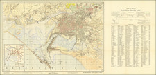
Highly detailed map of the Karachi, first published by the Survey of Pakistan in 1929.
The present example is the 4th edition and was offered for sale for 3 Rupees. It includes an exceptionally detailed color coded main map of the city, with a transit map at the lower left.
At the right is a detailed explanation of symbols, along with a key locating hundreds of places on the map, some specifically referenced and others simply located with a grid system.
The map shows Karachi shortly after the City became the Capital of Pakistan after it gained independence from the United Kingdom, and during a period when hundreds of thousands of Muslim refugees from India were fleeing the anti-Muslim pogroms.
![Tabula Asiae IX [Northern India & Pakistan]](https://storage.googleapis.com/raremaps/img/small/77557.jpg)
![[ Pakistan and Afghanistan ] Nona Asie Tabula [Ninth Map of Asia]](https://storage.googleapis.com/raremaps/img/small/101345.jpg)