|
||

|

|
|

|
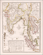
Fine original antique map of Surat, in the Indian state of Gujarat, published by John Luffman in 1800 for his Select Plans.
The map is attractively engraved and delicately colored, focusing on the town of Surat, showing the then-small city bounded by its two sets of walls. Nearby detail names smaller towns, many of which have now been agglomerated into the city. Soundings are shown in the Tapi River and in offshore shoals.
Surat was fully incorporated into the British East India Company only in the year that this map was published. It had been contested between the British and the Dutch, but British ascendancy in India corresponded to the end of the Dutch period in 1800. However, on the map, a Dutch Garden is named, reminiscent of this slightly earlier time.
Luffman's Select Plans is an uncommon traveler's guide that served to educate the intrepid traveler regarding any part of the world, from the major cities of Europe to the wild coasts of the Spice Islands. Each of Luffman's maps contained detailed coastal descriptions showing the major landmarks and cities, as well as basic but necessary navigational information. A number of the plates are critical for their representations of sites of battles during the French Revolutionary Wars. This plate appeared in the second of Luffman's two volumes.
![[Early Trekking Map] Latest Map of Kathmandu to Tibet](https://storage.googleapis.com/raremaps/img/small/51007.jpg)
![[ Tibet / Nepal / Himalyas ] Carte von Tibet nach den neuesten Nachrichten entworfen 1790](https://storage.googleapis.com/raremaps/img/small/86165.jpg)
![[Northwestern India & Pakistan] Tabula Asiae IX](https://storage.googleapis.com/raremaps/img/small/46402.jpg)