|
||

|

|
|

|
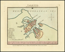
Valletta, Shortly after the British Conquest
A fine and scarce British-engraved map of Valletta and the Three Cities, issued in 1801 and referring to the 1800 British capture of the city from the French.
This delicately colored map shows Valletta on its peninsula, sandwiched between Marsamxett Harbor and Grand Harbor. A key refers to nine places of interest, with Fort Manoel, as well as a number of castles and other important military installations shown. The map is highly detailed, with walls, individual blocks, and important coastal points named.
This map was published shortly after the conclusion of the siege of Malta, which had started following the French capture of the city on Napoleon's route to Egypt. Shortly after, the French garrison that had been left there was put under siege, and faced with a Maltese uprising. The French held out for two years, but dwindling supplies and the growing British control of the Mediterranean made their position untenable. The fall of Malta would allow the British a foothold with which to capture Egypt, and the British would remain in Malta until 1964.
Luffman's Select Plans is an uncommon traveler's guide that served to educate the intrepid traveler regarding any part of the world, from the major cities of Europe to the wild coasts of the Spice Islands. Each of Luffman's maps contained detailed coastal descriptions showing the major landmarks and cities, as well as basic but necessary navigational information. A number of the plates are critical for their representations of sites of battles during the French Revolutionary Wars. This plate appeared in the second of Luffman's two volumes.
![Egypt and Barca [with] Abissina and Nubia [with] Congo. Angola. Cafres. Monoemugi. Monomotapa. Zanguebar & Madagascar](https://storage.googleapis.com/raremaps/img/small/78890.jpg)
![[ Malta ] Maltha](https://storage.googleapis.com/raremaps/img/small/98149.jpg)