|
||

|

|
|

|
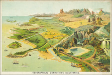
Fine color chromolithograph image showing the the use of natural and man-made Geographical and Geological terms.
Originally issued as an educational aid, Yaggy's charts are among the most distinctive and stunning comparative charts ever published. Unlike the smaller, simpler and more analytical comparative charts found in atlases, Yaggy's images present a living landscape set with an exaggerated scale which gives each a strange and other-worldly appearance. In the Ascending Regions the major mountain peaks from all continents (except Antarctica) are represented. Small mountaineering figures are used to indicate important ascents with the date and explorer's name including Humboldt (1802), Boussingault and Hall (1831) and Gerard's climb of Hindu Koh in 1818. Of special interest is the depiction of the balloon ascents of Gay Lussac and Green. Volcanoes are shown with fire, smoke and magma flows. The lower elevations fill the foreground with the elevation given from major cities including Denver, with the vegetation and local crops.
Yaggy's views are exquisite and scarce examples of multi-stone lithography with each stone carrying a different color ink to build up the image to a complex, beautiful image. We count at least six different colors and perhaps as many as eight.
![[Anne Du Bourg Confront the King Henri II and the Parliament of Paris in June 1559] Der Parlements hern gem in rath Mercu rialle gen ant bein Kugusinern ou Paris. . .](https://storage.googleapis.com/raremaps/img/small/78594.jpg)
![[ Early Infographic Chart ] Geography Epitomiz'd. Of The Stars And Planets. Of The Sun And Moon. Of the Air and Meteors. The Terms of Geography Explain'd.](https://storage.googleapis.com/raremaps/img/small/101679.jpg)
![Hemisphere Occidental ou du Nouveau Monde . . . [and] Hemisphere Oriental ou de L'Ancien Monde . . . MDCCLXI](https://storage.googleapis.com/raremaps/img/small/64273.jpg)