|
||

|

|
|

|
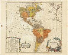
An Exceptionally Rare Six-Sheet Wall Map of the Americas. Virtually Unknown to Cartographic Scholars.
A very rare six-sheet wall map of the Americas, first issued by Alexis Hubert Jaillot in 1695, and here reissued in 1719 during the infamous Mississippi Bubble investment scheme, led by Scotish financier John Law.
The 1695 first state is known in one example at the Bibliotheque National de France, and was seemingly unknown to modern scholars, such as Burden (Mapping of North America) and McLauglin (Mapping of California as an Island). The present map is apparently the only surviving example of this 1719 second state, which has been extensively improved and updated as noted below.
This map was part of a series of wall maps of the continents prepared by Jaillot in the 1690s, which, because of their rarity, have not been previously appreciated as a central component of that mapmaker's oeuvre. In many ways, these maps represent the culmination of Jaillot's large-format mapping, which began with his L'Atlas Nouveau (conceived before 1670, and first issued in 1681).
This map was likely updated by Alexis Hubert Jaillot's son, Bernard-Jean-Hyacinthe. Many important changes have been made to the cartography compared to the first state of 1695. Namely, La Salle's unusual (and largely erroneous) mapping of the Mississippi River has been added. Bernard-Jean-Hyacinthe's uneasiness with the quickly-unraveling California as an Island myth is indicated by the ambiguity of its relationship to the rest of the continent - here riding the fence between island and peninsula. Furthermore, the Great Lakes have been cleaned up; whereas the 1695 state continued Sanson's open-ended lakes, here they are in more or less their recognizable modern form.
The Mississippi Bubble
This map matches Jaillot's large folio North America counterpart (Burden II, 438) in that its first major update came in 1719. This is no accident. The period from roughly 1719 to 1721 saw enormous change in the cartography of North America, spurred on by a financial bubble in France caused by the economic machinations of John Law and the Compagnie d’Occident and the Compagnie des Indes. Law's far-reaching and initially very successful moves saw him gain control over France's foreign trade and the country's finances. Law issued 625,000 shares in his ventures, and so many members of the public came to be invested in his schemes. A stock market boom ensued across much of Europe, but Law's expected profits did not materialize fast enough and in 1720 share prices collapsed dragging down the European economy. Law took much of the blame for what had occurred and fled France at the end of the year.
The Mississippi Bubble also resulted in a boom in the market for maps of North America, as the public sought information on the areas in which they were investing. This meant that many new maps were made, and older copper was revised to better suit the market of the day. It is for this reason that so many great maps of the continent were made during a relatively short period around 1720.
Rarity and States
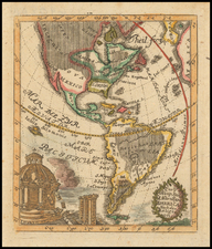
- First state. Dated 1695 in the title cartouche. With California definitively illustrated as an island. (BnF, only known example.)
- Second state. Dated 1719 in the title cartouche. California is now ambiguously illustrated, without a delineated northeast coast separating, or connecting, it to the rest of North America. The interior of North America has been updated with La Salle's Mississippi River information. (The present map. Only known example.)
- Third state. Dated 1782 in the title cartouche. The map appears otherwise unchanged from the 1719 state and in thus surprisingly out of date for its time.
- Fourth state. Dated 1783 in the title cartouche. Substantial changes have been made to the cartography of the Pacific and the Pacific Northwest though the map is still hopelessly out of date in much of the rest of North America. This is by far the most common state (with five institutional examples noted), which is somewhat surprising given the superior quality of competitive contemporary maps.
The final two states appeared after the Jaillot family business and copperplates were dispersed at auction in 1781. They were apparently repinted despite their antiquity, because doing so was cheaper than making up-to-date engravings.
Alexis-Hubert Jaillot (ca. 1632-1712) was one of the most important French cartographers of the seventeenth century. Jaillot traveled to Paris with his brother, Simon, in 1657, hoping to take advantage of Louis XIV's call to the artists and scientists of France to settle and work in Paris. Originally a sculptor, he married the daughter of Nicholas Berey, Jeanne Berey, in 1664, and went into partnership with Nicholas Sanson's sons. Beginning in 1669, he re-engraved and often enlarged many of Sanson's maps, filling in the gap left by the destruction of the Blaeu's printing establishment in 1672.
![[The Rarest State] Americae Sive Novi Orbis Nova Descriptio](https://storage.googleapis.com/raremaps/img/small/80521.jpg)
![Nov. Orbis sive America Septentrionalis . . [California as an Island]](https://storage.googleapis.com/raremaps/img/small/67439.jpg)