|
||

|

|
|

|
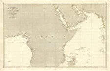
Mapping The Gulf In The Mid-18th Century
Scarce coastal chart of the Gulf, from Basrars to Cap de Jask and Kursekian.
The map shows several toponyms in the UAE, including Julfar, la Pagode blache, and Zaka.
The map shows a lot of detail around Bahrain and Qatar, including el Katif, Deh-Rogn, Lagune de Lahsa, Sa maka and Apas ou Pasteles.
The settlement on the island of Bahrain shown as "Deh-Rogn" is an early reference to Qatar; while "deh" means "village", "Rogn" signifies Ras Rakan at the northern tip of the Qatar peninsula, a prominent navigational landmark.
The reference to the Lagune de Lahsa and El Katif are remnant of the Lahsa Eyalet, which was a part of the Ottoman Empire, encompassed territories now within Saudi Arabia, Kuwait, and Qatar, with Al-Ahsa (Lahsa) and Qatif (El Katif) as its primary cities. It was established in the mid-16th century, primarily to protect trade routes in Basra from Portuguese disruptions in the Persian Gulf. Initially a district of Basra, it gained its own governor-general by 1560. The local Bani Khalid Emirate leaders often rebelled against Ottoman rule, leading to fluctuating control. By the late 1660s, under Barrak ibn Ghurayr ibn Uthman's leadership, the Bani Khalid decisively defeated the Ottomans, establishing the independent Bani Khalid Emirate in 1670.
Jean-Baptiste Bourguignon d’Anville (1697-1782) was one of the foremost French geographers of the eighteenth century. He carried out rigorous research in order to create his maps, which greatly developed the technical proficiency of mapmaking during his lifetime. His style was also simpler and less ornate than that of many of his predecessors. It was widely adopted by his contemporaries and successors.
The son of a tailor, d’Anville showed cartographic prowess from a young age; his first map, of Ancient Greece, was published when he was only fifteen years old. By twenty-two, he was appointed as one of the King’s géographes ordinaire de roi. He tutored the young Louis XV while in the service to the Crown. However, royal appointment did not pay all the bills, so d’Anville also did some work for the Portuguese Crown from 1724. For example, he helped to fill out Dom João V’s library with geographical works and made maps showing Portugal’s African colonies.
D’Anville disapproved of merely copying features from other maps, preferring instead to return to the texts upon which those maps were based to make his own depictions. This led him to embrace blank spaces for unknown areas and to reject names which were not supported by other sources. He also amassed a large personal map library and created a network of sources that included Jesuits in China and savants in Brazil. D’Anville’s historical approach to cartography resulted in magnificently detailed, yet modern and academic, maps. For example, his 1743 map of Italy improved upon all previous maps and included a memoir laying out his research and innovations. The geographer also specialized in ancient historical geography.
In 1773, d’Anville was named premier géographe de roi. In 1780, he ceded his considerable library to the Ministry of Foreign Affairs to be used for as a reference library for diplomats. D’Anville is best known for several maps, including his map of China, first published in 1735, and then included with Du Halde’s history of that country (the Hague, 1737). His map of Africa (1749) was used well into the nineteenth century.
![Turcicum Imperium . . . [shows Cyprus]](https://storage.googleapis.com/raremaps/img/small/91206.jpg)
![[Arabian Peninsula] Sexta Asie Tabula [Arabia Felix.]](https://storage.googleapis.com/raremaps/img/small/84313.jpg)