|
||

|

|
|

|
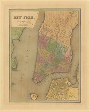
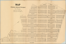
An Incomparable Record of One of the Upper West Side's First Hamlets.
Fantastic original manuscript survey map by William Bridges, perhaps the most important mapmaker in the history of Manhattan.
The map is oriented with northwest at the top. It covers an area roughly bounded by 67th Street in the south and 72nd Street in the north. In the east, the map shows [9th] Avenue (now Columbus Avenue), and in the west, it extends beyond [10th] Avenue (now Amsterdam Avenue).
This was conceived as a real estate map, showing the subdivision of lands in the estate of John Someringdyck (elsewhere spelled "Somerindyke") after his death, but these lots are not what gives the map its immediacy; it is most interesting as a document of an extremely early community ("Harsenville") on the Upper West Side, with a church, an inn, and stores. Some of the houses, such as "Mr. Talman's Seat", have a sprawling-estate quality, with verandas and auxiliary buildings ("Chaise house & Stable"), while others ("Mr. Holmes'", "Mr Tyson", "Mr. Gatfield", and "Mr Harsen") show the first hints of denser organization and urbanization - if it can be so-called.
This map brings to mind two pre-1820 mappings of Manhattan: the various Commissioners' Plans, for which Bridges was the initial publisher (though John Randel the primary surveyor), and the Randel Farm Surveys. While it is interesting to compare the present map with what is shown of the area on the aforementioned surveys, this map necessarily provides much more detail. John Bute Holmes reproduced some early (but still later) surveys of the area in his 1879 Map of Parts of Somerindyke, Harsen, Talman, Hardenbrook and Other Estates, and The Adjoining Water Grants.
Harsen Village got its name from Jacob Harsen (or an earlier member of his family) who owned much of the land shown here. The road here called "Cross Road" would be renamed "Harsen's Road" on the Randel Farm Surveys. The Harsen's lost some of their lands to eminent domain in 1849, as the city sought to expand Bloomingdale Road (present-day Broadway). Apparently, Harsenville was all but gone by the 1870s - New York Public Library has a drawing of some dilapidated homes titled "The last of Harsenville" from 1873. One source claims that at its largest, Harsenville had 500 residents and over 60 buildings, but that must have been later in the 19th century.
The Pelican Inn, which is clearly a focal point of the community, was previously called the Shakespeare Inn in 1803 and is also apparently referred to as the Oakley Tavern.
The "church lot" plot would come to house a Reformed Dutch Church shortly after the completion of the present map. This might have been the relocation from the smaller church shown here. This matches with what we know about the Bloomingdale Reformed Church, about which more can be read here.
The map was clearly used as a working real estate document for some time after its original production; there are numerous pencil notes relating to the leasing and sale of plots covered by the map ("Leased to Laver", "Leased to Dally", "Leased to Mrs. Pook", "for sale by Hoffman...").
The Bridges Family Survey Collection
Two of William Bridges's sons went on to be New York City surveyors as well. After the death of his son Joseph F. Bridges in 1883, the family survey collection was split up, but the core of the material was purchased by rare map dealer Richard D. Cooke in 1885. The City of New York tried to acquire the entire archive for the massive sum of $30,000, but negotiations ultimately failed and the maps were dispersed individually. At the time of the city's offer, the New York Real Estate Record and Builders' Guide (9 December 1899, pages 877-8), wrote:
[T]he Bridges collection . . . apart from books and manuscripts, is the most important source in existence for the history of New York City during three-quarters of a century. Besides, it has an extremely practical bearing on practical interests, for should the information it contains regarding old boundaries and surveys be lost, a cloud would be thrown upon many titles to real estate
It is unknown if this manuscript was in the Cooke collection, though that is a good bet.
Rarity
A group of much smaller survey field books from the Bridges family (most of them post-dating the elder Bridges's death), were sold by Swann Auctions in 2014 for $18,750.
To our knowledge, no large-format original surveys by Bridges have traded in recent memory (no examples located in RBH). The only appearance of the Commissioner's Plan (1821) in recent decades was also at Swann, in 2013, where it made $102,000.
William Bridges (1771 - July 10, 1814) was one of the foremost surveyors and mapmakers of early New York City. A native of England, Bridges probably arrived in the United States in either 1805 or 1806. This is known from his earliest record in the States, when he advertised as a tutor for architectural drawing from young men and women, in 1806. In that year he was also appointed City Surveyor for New York.
Bridges had a complicated and far from clean personal and professional record. In politics, he was a Federalist, and he in the course of his political activities he was accused of election fraud for apparently trying to force others to vote for his candidates.
In his professional life, he was dogged by similar controversy. Bridges is remembered today first as the publisher of the 1811 Commissioner's Plan of New York, which famously gave the city its grid. That map has been called "the single most important document in New York City's development" (Augustyn & Cohen, Manhattan in Maps). However, Bridges was not actually responsible for the surveys that resulted in the map; those were done by another man altogether, John Randel Jr. (1787-1865). Bridges enraged Randel by publishing the Commissioner's Plan crediting only himself. This resulted in a series of public arguments that lasted until Bridges's death in 1814. Despite the nefarious way in which he procured and published the map, Bridges managed to defend its copyright.
Bridges also issued a copy of the Mangin-Goerk Plan of New York, on which he similarly only credited himself.
In less than a decade in New York City, Bridges had a considerable influence on the history of the city, despite (or maybe because of) his dubious personal character.
For more on Bridges, see Marguerite Holloway's book The Measure of Manhattan.