|
||

|

|
|

|
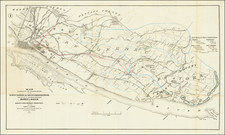
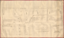
Transforming the Upper West Side from Rural to Urban.
Large manuscript real estate survey map of Harsenville on the Upper West Side of Manhattan.
The survey was made by New York City Surveyor John J. Serrell, and shows the progression of the hamlet of Harsenville (one of the first semi-urban areas of the Upper West Side) into the regimented, subdivided neighborhood that remains there today.
The map maintains some hints of the loose plot lines and uneven roads that can be seen on our 1810 map of the area.
We also have a further manuscript map of Harsen family property, though elsewhere in Manhattan.
John J. Serrell
John J. Serrell was City Surveyor in New York throughout the 1840s and '50s. Most of his maps seem to be focused on the Upper West Side and Midtown, which makes sense given the development of New York City in this period.
Serrell also surveyed for Jacob Harsen, M.D., the grandson of the owner of the present property. Those surveys can be differentiated by his use of "John Harsen, M.D." as opposed to "John Harsen, Decd."
John J.'s younger brother, John E. Serrell, was also a surveyor. Much of the latter's cartographic output is in the collections of the New York Public Library, in the Serrell-Opdycke-Patrick Papers, ca. 1828-1963.
Jacob Harsen
The Harsen family were among the earliest Dutch settlers of Manhattan.
The New York State Library includes papers of the Harsen and Dyckman families and gives the following biography of Jacob Harsen:
In 1773 Jacobus Harsen (1750-1835), the eldest son of Johannas Harsen and Rachel Dyckman Harsen, married Catharine Cozine (1750-1835), whose family had immigrated to Manhattan in 1684. The approximately 122-acre Cozine family estate, the title to which was given by the Duke of York, stretched between the North and East rivers in northern Manhattan that adjoined the Dyckman family estate. Jacobus Harsen, who is sometimes referred to by the Anglicized name "Jacob", was active in New York City's political life, serving as both alderman and city magistrate. Jacobus was also an active member of the Reformed Dutch Church, serving as a ruling elder.
Jacob's children and grandchildren were prominent in New York City life. His grandson, also Jacob (the one referred to on this map), was a prominent Manhattan physician.
"Harsenville" -- named for the family -- is a "lost village" of the Upper West Side. The website 6sqft gives the following description:
Harsenville ran from 68th Street to 81st Street, between Central Park West and the Hudson River. It began in 1701 when Cornelius Dyckman bought a 94-acre farm at Broadway and 73rd Street. His daughter Cornelia then married a farmer named Jacob Harsen, and they built their homestead at Tenth Avenue and 70th Street in 1763. Other farming families began to follow suit, setting up what became a small village, complete with schools, churches, and shops. At its height, it had 500 residents and 60 buildings, thanks largely to the perfect-for-tobacco soil and waterfront views. Harsenville Road was the main street, and it ran through present-day Central Park.
![[Harlem]. Map of the Harlaem Commons surveyed agreeably to the boundaries established by the Commissioners appointed to settle the boundary lines between the common lands of the City of New York and the Town of Harlaem...](https://storage.googleapis.com/raremaps/img/small/59385.jpg)