|
||

|

|
|

|
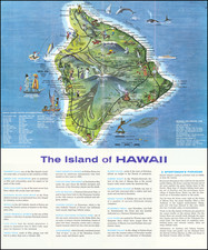
Decorative map of Hawaii, drawn by Parker Edwards for the Hawaiian Pineapple Company, and one of the most recognizable promotional maps of Hawaii published during its territorial period.
This map was published during the first serious push for Hawaii's statehood after the Jones-Costigan Act of 1935 threatened the Hawaiian sugar industry, limiting the territory's exports as a foreign insular possession. Hawaii's Big Five companies, including Castle & Cooke, owner of a large share of the Hawaiian Pineapple Company (producers of Dole canned pineapple), were a part of this push. However, concerns over Hawaii's large Japanese population proved to be a stumbling block, and consideration of statehood was tabled. Statehood was reconsidered once again in 1937 when a committee recommended a plebiscite.