


|
||

|

|
|

|
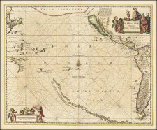
Beautiful example of the first scarce state of Jansson's map of the Pacific, the first map of the Pacific to show California as an Island and the earliest map of the Pacific to appear in a Dutch Atlas.
A long chain of islands appear in the South Pacific, which are likely a vestige of Terra Australis by are noted by Jansson to have been discovered by Hernando Gallego in 1576. Marvelous treatment of Australia, which is then only partially known. While based upon the Briggs model, the lack of the 2nd Punta de la Concepcion suggests reliance upon Goos or his sources. The large Terra Incognita in the Northwest nearly connects Asia with the Island of California, separated only by the Fretum (Strait) Anian. Many place names in California. Nice treatment of the Ladrones and neighboring islands, along with the West Coast of America. An essential map for Pacific Collectors.
De Wit (1629 ca.-1706) was a mapmaker and mapseller who was born in Gouda but who worked and died in Amsterdam. He moved to the city in 1648, where he opened a printing operation under the name of The Three Crabs; later, he changed the name of his shop to The White Chart. From the 1660s onward, he published atlases with a variety of maps; he is best known for these atlases and his Dutch town maps. After Frederik’s death in 1706, his wife Maria ran the shop for four years before selling it. Their son, Franciscus, was a stockfish merchant and had no interest in the map shop. At the auction to liquidate the de Wit stock, most of the plates went to Pieter Mortier, whose firm eventually became Covens & Mortier, one of the biggest cartography houses of the eighteenth century.

![[Mission San Luis Rey] Vue de La Mission de Saint Louis Roi De France](https://storage.googleapis.com/raremaps/img/small/71720.jpg)

