This item has been sold, but you can enter your email address to be notified if another example becomes available.


|
||

|

|
|

|
Stock# 80743
Description
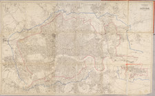
Nice example of Langley & Belch's scarce decorative plan of London, featuring 24 vignettes of major landmarks around the city.
The map stretches from Hyde Park in the west to the Isle of Dogs in the east. It is one of the more data-rich maps of London from this period, using colors and symbols to illustrate different concepts in the fast-changing city. A number of planned roads and bridges are illustrated.
Langley & Belch's map was one of the most visually appealing maps of London of the period. Both the West India Docks and East India Docks are illustrated, having been built in 1802 and 1806 respectively.
States
According to Darlington & Howgego, the map was first issued in 1812 and was issued in at least 5 states up to 1826.
Condition Description
Original hand-color. Dissected and mounted on original linen, with original paper case (worn) with engraved label.
Reference
Howgego 256, 2nd state (of 5).