


|
||

|

|
|

|
Maps as Geography Lesson, and Art
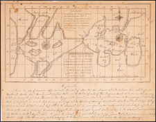
Fantastic manuscript map showing a variety of geographic features spread on an imaginary landscape. Annotated in both French and Dutch, the piece is a showcase of a young pupil’s mastery of language, cartography, and geography.
The work is most likely the successful completion of a school assignment from ca. 1900 wherein the child had to illustrate a long list of features, including volcanoes, dunes, and a drawbridge. Executed with a fine eye for detail and artistic flair, the map preserves the work of a student from over a hundred years ago.
The map almost certainly dates from the late-nineteenth century, given the handwriting and language. The lack of tractors suggests that the map comes from before their advent and spread, which suggests that the object likely dates to ca. 1915 at the latest. A small steamboat can be found in the inland sea, confirming the common use of that technology.
Most details have a French name (first) and a Dutch name (second). For example, the mer is also the zee, ville is also stad, kust and cotes, port and haven, and so on. The detail on the map is truly marvelous, with calm waters and tranquil meadows, impressive rock structures and lush gardens. There are even windmills on an offshore island, again suggesting a Dutch origin.
Children have been set creative geography lessons for centuries. Earlier in the nineteenth century, girls’ schools and tutors had young ladies embroider map as samplers. This student seems to have had an especial penchant for precision and artistry, creating a map that is a delight to see.

![[Troops in the Mountains of North America] Nordamericanische Truppen auf einem Gebirgszug](https://storage.googleapis.com/raremaps/img/small/91333.jpg)
![[ Spanish Flu -- Masks -- Armistance Day WWI ] The Unveiling of The Kaiser's Finish By Capt. J.F. Mora At Pittsburg, Calif, Nov 17th, 1918.](https://storage.googleapis.com/raremaps/img/small/99630.jpg)