


|
||

|

|
|

|
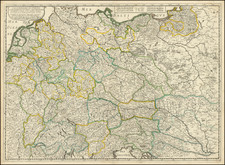
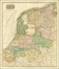
Fantastic antique map of Central Europe, focused on Germany and showing the whole of the Netherlands, Czechoslovakia, and Austria, as well as parts of Northern Italy, Denmark, France, and Belgium. The map was made by Nicholas Sanson and published in Paris in 1645 by Pierre Mariette, an important 17th-century French cartographer. The title cartouche also credits Melchior Tavernier as a (seemingly earlier) publisher of the map.
Detail on the map is extensive, with a number of cities, rivers, and other geographical features shown. The map is colored and demarcated according to regions, which are also named.
1645 was an interesting time in Central Europe, positioned at the end of the Thirty Years War. One of the most disastrous conflicts in European history, the war was starting to wind down to an end as more and more European armies were disintegrating. The war would end in 1648 with the Swedish Siege of Prague.
Melchior Tavernier was a member of a large family involved in the publishing trade in Paris in the early years of the seventeenth century. Early in his career, he apparently collaborated with Henricus Hondius, as at least one of his early maps references Tavernier as the seller of a map engraved in Amsterdam, by Hondius. He is probably best known for his publication of a map of the Post Roads of France, which was copied many times until the end of the century. He also issued an atlas under the same title as J. le Clerc's Theatre Geographique, using many of Le Clerc's maps, but incorporating others from different sources. He published composite atlases and also published works for other cartographers, including N. Sanson, N. Tassin, and P. Bertius. He is not to be confused with his nephew of the same name (1594-1665), who also engraved maps for Nicolas Sanson.
Nicholas Sanson (1600-1667) is considered the father of French cartography in its golden age from the mid-seventeenth century to the mid-eighteenth. Over the course of his career he produced over 300 maps; they are known for their clean style and extensive research. Sanson was largely responsible for beginning the shift of cartographic production and excellence from Amsterdam to Paris in the later-seventeenth century.
Sanson was born in Abbeville in Picardy. He made his first map at age twenty, a wall map of ancient Gaul. Upon moving to Paris, he gained the attention of Cardinal Richelieu, who made an introduction of Sanson to King Louis XIII. This led to Sanson's tutoring of the king and the granting of the title ingenieur-geographe du roi.
His success can be chalked up to his geographic and research skills, but also to his partnership with Pierre Mariette. Early in his career, Sanson worked primarily with the publisher Melchior Tavernier. Mariette purchased Tavernier’s business in 1644. Sanson worked with Mariette until 1657, when the latter died. Mariette’s son, also Pierre, helped to publish the Cartes générales de toutes les parties du monde (1658), Sanson' atlas and the first French world atlas.
![Vienna [Wien]](https://storage.googleapis.com/raremaps/img/small/93386.jpg)
![[Napoleon's Battles in France, Belgium Netherlands, Luxembourg, Germany] No. 1 Frontiere du Nord. Mesny 5.](https://storage.googleapis.com/raremaps/img/small/60727.jpg)